IMAGES TAKEN NEAR TO
Corran Way, SOUTH OCKENDON, RM15 6AP
Introduction
This page details the photographs taken nearby to Corran Way, RM15 6AP by members of the Geograph project.
The Geograph project started in 2005 with the aim of publishing, organising and preserving representative images for every square kilometre of Great Britain, Ireland and the Isle of Man.

There are currently over 7.5m images from over14,400 individuals and you can help contribute to the project by visiting https://www.geograph.org.uk
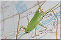
Image Map (Loading...)


Getting Data...Please wait
Leaflet Map data © OpenStreetMap
Images are licensed for reuse under creativecommons.org/licenses/by-sa/2.0
Notes
- Clicking on the map will re-center to the selected point.
- The higher the marker number, the further away the image location is from the centre of the postcode.
Image Listing (51 Images Found)
Images are licensed for reuse under creativecommons.org/licenses/by-sa/2.0
Image
Details
Distance
1
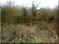
Across the Mardike Valley
Looking across the Mardike Valley towards Davy Down http://www.davydown.org.uk/. The concrete footings in the foreground used to be an electricity substation. This is now replaced by the small transformer on the electricity pole.
Image: © Glyn Baker
Taken: 10 Jan 2010
0.06 miles
2
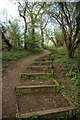
Steps From The Park
These steps lead from the Mardyke River valley to Cullen Square
Image: © Glyn Baker
Taken: 10 Apr 2007
0.07 miles
3
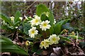
Primula vulgaris
These Primroses are in Brannets Wood part of Thames Chase http://www.thameschase.org.uk/what.html
Image: © Glyn Baker
Taken: 10 Apr 2007
0.08 miles
4
Geographers Little Helper
This little fella came along to help while uploading some photos. I think he is a Long-winged cone head cricket Conocephalus discolor
Image: © Glyn Baker
Taken: 7 Aug 2009
0.10 miles
5
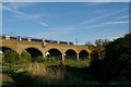
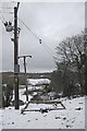
Viaduct and Electrostar
This is the viaduct over the Mardike Valley. The 357 Electrostar train is heading for Chafford Hundred (& Lakeside). For more info on the viaduct see
Image
Image: © Glyn Baker
Taken: 7 May 2007
0.11 miles
6

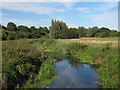
Reed Mace & Mardike
Looking upstream towards Stifford Bridge
Image: © Glyn Baker
Taken: 24 Mar 2020
0.11 miles
7
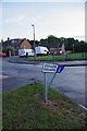
Cullen Square (After The Flood)
The houses in the background are built on a U shaped hill. The homes at the bottom of the U ended up with 2 feet of water through their ground floors. I walked past the sign a few hours earlier and didn't notice if it was bent or not.
Image: © Glyn Baker
Taken: 20 Jun 2020
0.13 miles
8
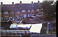
Gardens in Cherwell Grove
Looking from Corran Way into the back Gardens of Cherwell Grove
Image: © Glyn Baker
Taken: Unknown
0.13 miles
9
Mar Dyke
Seen from the bridge from Davy Down leading to the Mardyke Way.
The Mar Dyke is also known as Mardyke: The name means "boundary ditch".
Image: © Roger Jones
Taken: 8 Sep 2012
0.14 miles