IMAGES TAKEN NEAR TO
Humber Avenue, SOUTH OCKENDON, RM15 5JT
Introduction
This page details the photographs taken nearby to Humber Avenue, RM15 5JT by members of the Geograph project.
The Geograph project started in 2005 with the aim of publishing, organising and preserving representative images for every square kilometre of Great Britain, Ireland and the Isle of Man.

There are currently over 7.5m images from over14,400 individuals and you can help contribute to the project by visiting https://www.geograph.org.uk
Image Map
Images are licensed for reuse under creativecommons.org/licenses/by-sa/2.0
Notes
- Clicking on the map will re-center to the selected point.
- The higher the marker number, the further away the image location is from the centre of the postcode.
Image Listing (31 Images Found)
Images are licensed for reuse under creativecommons.org/licenses/by-sa/2.0
Image
Details
Distance
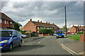
1
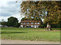
Houses, South Ockendon
Looking cross a small green from Gatehope Drive.
Image: © Robin Webster
Taken: 18 Sep 2011
0.02 miles
2
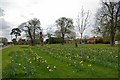
Garron Lane Green
Why is it that councils seem to love to plant flowers in straight lines?
Image: © Glyn Baker
Taken: 30 Mar 2008
0.05 miles
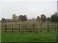
3
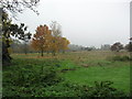
Ash Plantation
Woodland on the edge of South Ockenden.
Image: © Burgess Von Thunen
Taken: 23 Oct 2012
0.11 miles
4

Horses on the way to Belhus Park
The park is the other side of the M25, and this side is a strip of land which is a developing Oak and Ash plantation.
Image: © Robin Webster
Taken: 18 Sep 2011
0.12 miles
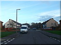
5
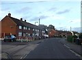
Fullerton Crescent, South Ockendon
Curved road with housing towards Foyle Drive.
Image: © David Anstiss
Taken: 25 Nov 2012
0.13 miles
6

Tracks In the Ash Plantation
If one can drive a normal saloon car across a grass field without getting stuck I can't fathom, why the school a few hundred yards away was closed due to the "severe weather". I hate to think what would happen to this country if we had a repeat of the winter conditions of 1940, 1947 or 1962/63 (thankfully I am too young to actually remember any of those but I do recall older people talking about the sea freezing at Mersea Island in 1947 and my father saying in 1940 he walked through the village of Edgeworth in Lancashire looking into the first floor bedroom windows of the workers cottages because the snow was so deep).
Image: © Glyn Baker
Taken: 28 Feb 2018
0.13 miles
7
Fullarton Crescent, South Ockendon
Very nearly a semicircle, from and to Foyle Drive. Here bisected by Gatehope Drive.
Image: © Robin Webster
Taken: 18 Sep 2011
0.13 miles
8
Ash Plantation
Woodlands designed by Capability Brown.
Image: © Burgess Von Thunen
Taken: 23 Oct 2012
0.15 miles
9
Gatehope Drive, South Ockendon
This road leads to Foyle Drive from Fullarton Crescent.
In the background is Dilkes Park.
Image: © David Anstiss
Taken: 25 Nov 2012
0.15 miles
10

Humber Avenue & Oakwood
Looking along Humber Avenue with Oakwood to the left. Oakwood and Ash plantation are part of a public open space owned and managed by Thurrock Council
Image: © Glyn Baker
Taken: 21 Jan 2013
0.16 miles