IMAGES TAKEN NEAR TO
Araglen Avenue, SOUTH OCKENDON, RM15 5DA
Introduction
This page details the photographs taken nearby to Araglen Avenue, RM15 5DA by members of the Geograph project.
The Geograph project started in 2005 with the aim of publishing, organising and preserving representative images for every square kilometre of Great Britain, Ireland and the Isle of Man.

There are currently over 7.5m images from over14,400 individuals and you can help contribute to the project by visiting https://www.geograph.org.uk
Image Map
Images are licensed for reuse under creativecommons.org/licenses/by-sa/2.0
Notes
- Clicking on the map will re-center to the selected point.
- The higher the marker number, the further away the image location is from the centre of the postcode.
Image Listing (4 Images Found)
Images are licensed for reuse under creativecommons.org/licenses/by-sa/2.0
Image
Details
Distance
2
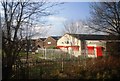
Chestnut Tree Farm
Chestnut Tree Farm Garden centre at the junction of South Road and Buckles Lane
Image: © Glyn Baker
Taken: 24 Mar 2008
0.22 miles
3
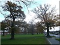
Bonnygate Wood, South Ockendon
Rectangular grass area, scattered with trees beside Daiglen Drive.
Image: © David Anstiss
Taken: 25 Nov 2012
0.23 miles
4
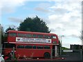
Chestnut Farm Bus
As seen from South Road.
Currently a display for Xmas lights.
Image: © David Anstiss
Taken: 25 Nov 2012
0.23 miles