IMAGES TAKEN NEAR TO
London Road, SOUTH OCKENDON, RM15 4XU
Introduction
This page details the photographs taken nearby to London Road, RM15 4XU by members of the Geograph project.
The Geograph project started in 2005 with the aim of publishing, organising and preserving representative images for every square kilometre of Great Britain, Ireland and the Isle of Man.

There are currently over 7.5m images from over14,400 individuals and you can help contribute to the project by visiting https://www.geograph.org.uk
Image Map
Images are licensed for reuse under creativecommons.org/licenses/by-sa/2.0
Notes
- Clicking on the map will re-center to the selected point.
- The higher the marker number, the further away the image location is from the centre of the postcode.
Image Listing (29 Images Found)
Images are licensed for reuse under creativecommons.org/licenses/by-sa/2.0
Image
Details
Distance
1

Benchmark on 'Montague', London Road
Ordnance Survey cut mark benchmark described on the Bench Mark Database at http://www.bench-marks.org.uk/bm36089
Image: © Roger Templeman
Taken: 21 Nov 2010
0.01 miles
2
New Tank Hill Road bridge, viewed from Rainham Marshes Nature Reserve
View taken looking east.
Image: © Robert Lamb
Taken: 25 Jun 2010
0.10 miles
3
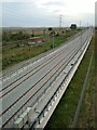
Wot No Trains? (Channel Tunnel Rail Link)
The picture was taken from the road bridge in New Tank Hill Road Purfleet looking west towards Rainham the link is due to open some time in 2007.
Image: © Glyn Baker
Taken: 11 Aug 2005
0.12 miles

5

Fann's Farm, Purfleet
As seen from a footpath passing through the farm between Purfleet and Aveley.
Image: © David Anstiss
Taken: 7 Nov 2012
0.13 miles


8

The Path to Purfleet
Image: © Glyn Baker
Taken: 18 Nov 2018
0.18 miles
9

Tilbury Line Pedestrian Crossing
In the background is the noise abatement boarding for the Channel Tunnel Rail Link.
Image: © Glyn Baker
Taken: 18 Nov 2018
0.18 miles
10

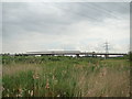
Pylons on the edge of Rainham Marshes
One corner of the nature reserve abuts railway lines and the line of pylons
Image: © David Smith
Taken: 10 Aug 2016
0.18 miles