IMAGES TAKEN NEAR TO
Hall Road, SOUTH OCKENDON, RM15 4HD
Introduction
This page details the photographs taken nearby to Hall Road, RM15 4HD by members of the Geograph project.
The Geograph project started in 2005 with the aim of publishing, organising and preserving representative images for every square kilometre of Great Britain, Ireland and the Isle of Man.

There are currently over 7.5m images from over14,400 individuals and you can help contribute to the project by visiting https://www.geograph.org.uk
Image Map
Images are licensed for reuse under creativecommons.org/licenses/by-sa/2.0
Notes
- Clicking on the map will re-center to the selected point.
- The higher the marker number, the further away the image location is from the centre of the postcode.
Image Listing (40 Images Found)
Images are licensed for reuse under creativecommons.org/licenses/by-sa/2.0
Image
Details
Distance
1
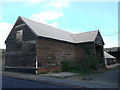
Aveley Hall Farm Barn
Large unconverted timber barn on Ship Lane.
Image: © David Anstiss
Taken: 7 Nov 2012
0.09 miles
2
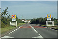
Welcome to Aveley
The Ship Lane approach to the village.
Image: © Robin Webster
Taken: 15 Sep 2011
0.12 miles