IMAGES TAKEN NEAR TO
Fen Lane, UPMINSTER, RM14 3RB
Introduction
This page details the photographs taken nearby to Fen Lane, RM14 3RB by members of the Geograph project.
The Geograph project started in 2005 with the aim of publishing, organising and preserving representative images for every square kilometre of Great Britain, Ireland and the Isle of Man.

There are currently over 7.5m images from over14,400 individuals and you can help contribute to the project by visiting https://www.geograph.org.uk
Image Map (Loading...)


Getting Data...Please wait
Leaflet Map data © OpenStreetMap
Images are licensed for reuse under creativecommons.org/licenses/by-sa/2.0
Notes
- Clicking on the map will re-center to the selected point.
- The higher the marker number, the further away the image location is from the centre of the postcode.
Image Listing (31 Images Found)
Images are licensed for reuse under creativecommons.org/licenses/by-sa/2.0
Image
Details
Distance

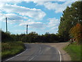
3
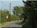
Fen Lane, near North Ockendon
Fen Lane, approaching a sharp double bend.
Image: © Malc McDonald
Taken: 27 Aug 2017
0.04 miles
5
Fen Lane, near North Ockendon
A sharp bend on Fen Lane, near North Ockendon.
Image: © Malc McDonald
Taken: 27 Aug 2017
0.07 miles
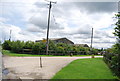
6
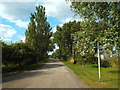
Farm driveway near North Ockendon
The signpost to the right of the image indicates that this driveway leading to a farm is a public right of way for people on foot.
Image: © Malc McDonald
Taken: 27 Aug 2017
0.08 miles