IMAGES TAKEN NEAR TO
Bletchingley Road, GODSTONE, RH9 8LL
Introduction
This page details the photographs taken nearby to Bletchingley Road, RH9 8LL by members of the Geograph project.
The Geograph project started in 2005 with the aim of publishing, organising and preserving representative images for every square kilometre of Great Britain, Ireland and the Isle of Man.

There are currently over 7.5m images from over14,400 individuals and you can help contribute to the project by visiting https://www.geograph.org.uk
Image Map
Images are licensed for reuse under creativecommons.org/licenses/by-sa/2.0
Notes
- Clicking on the map will re-center to the selected point.
- The higher the marker number, the further away the image location is from the centre of the postcode.
Image Listing (169 Images Found)
Images are licensed for reuse under creativecommons.org/licenses/by-sa/2.0
Image
Details
Distance
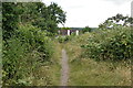
1
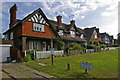
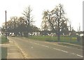
Green View
A row of pre-war cottages alongside Bletchingley Road, overlooking Godstone Green. Note the old style Vehicles Prohibited sign.
Image: © Ian Capper
Taken: 25 Jun 2010
0.01 miles
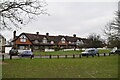
6
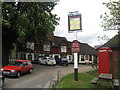
The Hare and Hounds public house, Godstone
Image: © Richard Rogerson
Taken: 11 May 2010
0.03 miles
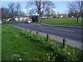
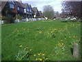
9
The Green, Godstone in 1987
Ivy Mill Lane (marked by road signs either side of its entrance) is shown entering Bletchingley Road (A25).
Image: © John Baker
Taken: 11 Apr 1987
0.05 miles
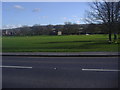
10
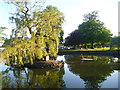
Godstone: Town Pond
A heron sits undisturbed waiting to catch his supper
Image: © Dr Neil Clifton
Taken: 4 Jun 2015
0.05 miles