IMAGES TAKEN NEAR TO
Lower South Park, GODSTONE, RH9 8LF
Introduction
This page details the photographs taken nearby to Lower South Park, RH9 8LF by members of the Geograph project.
The Geograph project started in 2005 with the aim of publishing, organising and preserving representative images for every square kilometre of Great Britain, Ireland and the Isle of Man.

There are currently over 7.5m images from over14,400 individuals and you can help contribute to the project by visiting https://www.geograph.org.uk
Image Map
Images are licensed for reuse under creativecommons.org/licenses/by-sa/2.0
Notes
- Clicking on the map will re-center to the selected point.
- The higher the marker number, the further away the image location is from the centre of the postcode.
Image Listing (21 Images Found)
Images are licensed for reuse under creativecommons.org/licenses/by-sa/2.0
Image
Details
Distance
1
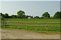
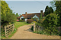
Towards Fidler's Grove
Looking across paddocks to Fidler's Grove, the house in the background.
Image: © Ian Capper
Taken: 25 Apr 2011
0.14 miles
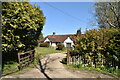
5
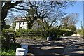
Cox's Bounty
A cottage at Lower South Park
Image: © Ian Capper
Taken: 25 Apr 2011
0.18 miles
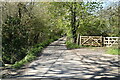
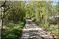
10
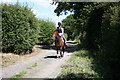
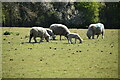
Lane past Tanglewood Stables, Surrey
Go for a ramble or cycle ride in this part of Surrey and you will very likely see more horses than cows, sheep or even motor cars. And most of the animals will be in first-class condition as befits this important horse-breeding and rearing area.
Image: © Dr Neil Clifton
Taken: 8 Aug 2006
0.22 miles