IMAGES TAKEN NEAR TO
Whitewood Lane, GODSTONE, RH9 8JR
Introduction
This page details the photographs taken nearby to Whitewood Lane, RH9 8JR by members of the Geograph project.
The Geograph project started in 2005 with the aim of publishing, organising and preserving representative images for every square kilometre of Great Britain, Ireland and the Isle of Man.

There are currently over 7.5m images from over14,400 individuals and you can help contribute to the project by visiting https://www.geograph.org.uk
Image Map
Images are licensed for reuse under creativecommons.org/licenses/by-sa/2.0
Notes
- Clicking on the map will re-center to the selected point.
- The higher the marker number, the further away the image location is from the centre of the postcode.
Image Listing (18 Images Found)
Images are licensed for reuse under creativecommons.org/licenses/by-sa/2.0
Image
Details
Distance
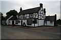
2
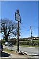
The Jolly Farmer
in Whitewood Lane, South Godstone. A circular, convex mirror stands opposite the pub to help motorists leaving the car park. This is actually an image in that mirror - see bottom left.
Image: © Roger W Haworth
Taken: 3 May 2006
0.10 miles
5
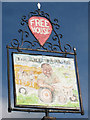
The Jolly Farmer sign
A well faded sign on Image
Image: © Oast House Archive
Taken: 6 Oct 2010
0.12 miles
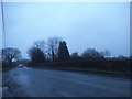
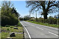
6
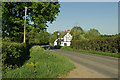
Tedham Lane
This is Godstone Bridleway 294.
Image: © Glyn Baker
Taken: 27 Sep 2023
0.13 miles
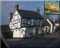
7
The Jolly Farmer
An 18th century building, used as a pub since at least 1851. Designated by Tandridge District Council as a building of character, their equivalent of local listing.
Image: © Ian Capper
Taken: 27 Apr 2011
0.13 miles
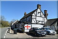
8
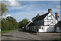
The Jolly Farmer, Horne
Pub on Whitewood Lane.
Image: © Oast House Archive
Taken: 6 Oct 2010
0.13 miles