IMAGES TAKEN NEAR TO
Danemore Lane, GODSTONE, RH9 8JF
Introduction
This page details the photographs taken nearby to Danemore Lane, RH9 8JF by members of the Geograph project.
The Geograph project started in 2005 with the aim of publishing, organising and preserving representative images for every square kilometre of Great Britain, Ireland and the Isle of Man.

There are currently over 7.5m images from over14,400 individuals and you can help contribute to the project by visiting https://www.geograph.org.uk
Image Map
Images are licensed for reuse under creativecommons.org/licenses/by-sa/2.0
Notes
- Clicking on the map will re-center to the selected point.
- The higher the marker number, the further away the image location is from the centre of the postcode.
Image Listing (21 Images Found)
Images are licensed for reuse under creativecommons.org/licenses/by-sa/2.0
Image
Details
Distance
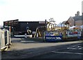
4
Eastbourne Road, (A22) Blindley Heath
Image: © Stacey Harris
Taken: 30 Mar 2011
0.13 miles
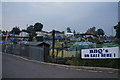
5
Entrance to S.K. Camping, Blindley Heath
Image: © nick macneill
Taken: 11 Jan 2013
0.13 miles
6
Eastbourne Road, (A22) Blindley Heath
Image: © Stacey Harris
Taken: 30 Mar 2011
0.13 miles
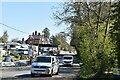
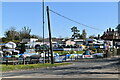
9
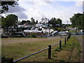
S K Camping and Leisure, Anglefield Corner, Surrey
On the A22 south of Godstone. A vast range of equipment for the outdoor holiday enthusiast. There is also a garden centre adjoining.
Image: © Dr Neil Clifton
Taken: 30 Jul 2006
0.15 miles
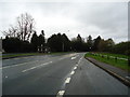
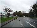
10
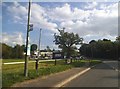
Bus stop on Eastbourne Road, Blindley Heath
Image: © David Howard
Taken: 20 Sep 2015
0.15 miles