IMAGES TAKEN NEAR TO
Eastbourne Road, GODSTONE, RH9 8EL
Introduction
This page details the photographs taken nearby to Eastbourne Road, RH9 8EL by members of the Geograph project.
The Geograph project started in 2005 with the aim of publishing, organising and preserving representative images for every square kilometre of Great Britain, Ireland and the Isle of Man.

There are currently over 7.5m images from over14,400 individuals and you can help contribute to the project by visiting https://www.geograph.org.uk
Image Map
Images are licensed for reuse under creativecommons.org/licenses/by-sa/2.0
Notes
- Clicking on the map will re-center to the selected point.
- The higher the marker number, the further away the image location is from the centre of the postcode.
Image Listing (8 Images Found)
Images are licensed for reuse under creativecommons.org/licenses/by-sa/2.0
Image
Details
Distance
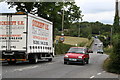
1
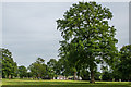
Posterngate Farm
Farmland in Hart's Lane with a number of light industrial units/offices on the site.
Image: © Ian Capper
Taken: 6 Jun 2014
0.05 miles
2
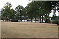
Posterngate Farm, South Godstone, Surrey
Part of the extensive grounds of Posterngate Farm, where the many activities include the maintenance of a herd of pedigree Charollais, and a lake for trout fishing. There is even a small business park.
And this photograph 'wraps up' the TQ34 hectad, of which I have claimed 48 first geographs.
Image: © Dr Neil Clifton
Taken: 18 Aug 2006
0.07 miles
4
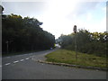
Eastbourne Road at the junction with Miles Lane
Image: © David Howard
Taken: 20 Sep 2015
0.15 miles
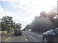
5
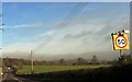
Surrey: The A22 at Harts Hill
Continuous heavy traffic passes along this part of the A22. Here we are looking northwards.
Image: © Dr Neil Clifton
Taken: 18 Aug 2006
0.17 miles
6
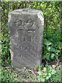
Old Milestone by the A22, Eastbourne Road, south of Godstone
Carved stone post by the A22, in parish of GODSTONE (TANDRIDGE District), Eastbourne Road, junction with Hart Lane, on grass verge, on West side of road. Godstone stone, erected by the Godstone & Highgate turnpike trust in the 18th century.
Inscription reads:-
22
MILES
FROM
CORNHILL
Carved bench mark on lower face.
Grade II Listed by Historic England, list entry number: 1472846 https://historicengland.org.uk/listing/the-list/list-entry/1472846
Milestone Society National ID: SY_LL22
Image: © L Joseph & RS Payne
Taken: 1 May 2006
0.23 miles
8
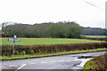
At the junction
New Road meets Miles Lane. Paygate Wood is ahead.
Image: © Robin Webster
Taken: 24 Jan 2010
0.24 miles