IMAGES TAKEN NEAR TO
Tandridge Hill Lane, GODSTONE, RH9 8DD
Introduction
This page details the photographs taken nearby to Tandridge Hill Lane, RH9 8DD by members of the Geograph project.
The Geograph project started in 2005 with the aim of publishing, organising and preserving representative images for every square kilometre of Great Britain, Ireland and the Isle of Man.

There are currently over 7.5m images from over14,400 individuals and you can help contribute to the project by visiting https://www.geograph.org.uk
Image Map
Images are licensed for reuse under creativecommons.org/licenses/by-sa/2.0
Notes
- Clicking on the map will re-center to the selected point.
- The higher the marker number, the further away the image location is from the centre of the postcode.
Image Listing (22 Images Found)
Images are licensed for reuse under creativecommons.org/licenses/by-sa/2.0
Image
Details
Distance
1
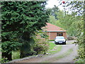
Off Tandridgehill Lane: North Model Farm
Image: © Dr Neil Clifton
Taken: 7 Oct 2014
0.08 miles
2
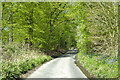
Tandridge Hill Lane
A narrow way up to the top of the North Downs.
Image: © Robin Webster
Taken: 22 Apr 2021
0.12 miles
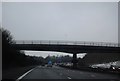
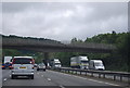
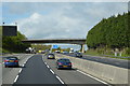
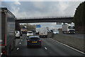
4
Tandridge Hill Lane Bridge, Anti-clockwise M25
Image: © David Dixon
Taken: 17 May 2013
0.14 miles
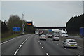
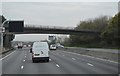
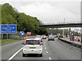
10
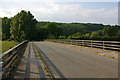
Tandridge Hill Lane overbridge
Tandridge Hill Lane is a narrow single track lane. Yet where it crosses the M25, this wide bridge was built. Unnecessary over-engineering?
Image: © Ian Capper
Taken: 25 Jun 2010
0.14 miles