IMAGES TAKEN NEAR TO
Bourne Mews, GODSTONE, RH9 8AR
Introduction
This page details the photographs taken nearby to Bourne Mews, RH9 8AR by members of the Geograph project.
The Geograph project started in 2005 with the aim of publishing, organising and preserving representative images for every square kilometre of Great Britain, Ireland and the Isle of Man.

There are currently over 7.5m images from over14,400 individuals and you can help contribute to the project by visiting https://www.geograph.org.uk
Image Map
Images are licensed for reuse under creativecommons.org/licenses/by-sa/2.0
Notes
- Clicking on the map will re-center to the selected point.
- The higher the marker number, the further away the image location is from the centre of the postcode.
Image Listing (31 Images Found)
Images are licensed for reuse under creativecommons.org/licenses/by-sa/2.0
Image
Details
Distance
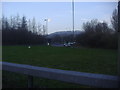
1
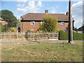
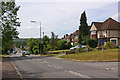
Selbourne Square
Part of an estate in Tyler's Green, the northern part of Godstone.
Image: © Ian Capper
Taken: 3 Jul 2010
0.04 miles
4
Godstone Hill
The old A22, prior to the building of the Godstone bypass. Looking down towards Godstone itself.
Image: © Ian Capper
Taken: 3 Jul 2010
0.08 miles
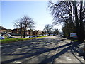
5
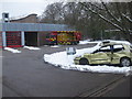
Godstone Fire Station, Godstone Hill
Road safety psychology outside the station seen by drivers as they approach the slip roads of M25 Junction 6 (Godstone Interchange).
Image: © Rib
Taken: 12 Jan 2010
0.09 miles
6
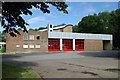
Godstone fire station
Godstone fire station, Fosterdown, Godstone, Surrey
Image: © Kevin Hale
Taken: 17 Jun 2007
0.11 miles
7
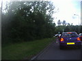
Approaching the M25 on the A22 in Godstone
Image: © David Howard
Taken: 13 Jun 2011
0.15 miles
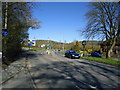
8
A22 roundabout with the M25, Godstone
The North Downs are in the distance
Image: © David Howard
Taken: 26 Mar 2012
0.15 miles