IMAGES TAKEN NEAR TO
Oxted Road, GODSTONE, RH9 8AD
Introduction
This page details the photographs taken nearby to Oxted Road, RH9 8AD by members of the Geograph project.
The Geograph project started in 2005 with the aim of publishing, organising and preserving representative images for every square kilometre of Great Britain, Ireland and the Isle of Man.

There are currently over 7.5m images from over14,400 individuals and you can help contribute to the project by visiting https://www.geograph.org.uk
Image Map
Images are licensed for reuse under creativecommons.org/licenses/by-sa/2.0
Notes
- Clicking on the map will re-center to the selected point.
- The higher the marker number, the further away the image location is from the centre of the postcode.
Image Listing (49 Images Found)
Images are licensed for reuse under creativecommons.org/licenses/by-sa/2.0
Image
Details
Distance
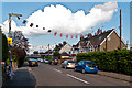
1
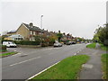
Oxted Road, Godstone
Oxted Road, heading into the village of Godstone in Surrey. This road forms part of the route of the A25.
Image: © Malc McDonald
Taken: 12 Oct 2019
0.05 miles
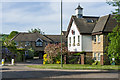
3
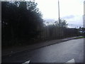
Salisbury Road, Godstone
Salisbury Road in the village of Godstone, in Surrey.
Image: © Malc McDonald
Taken: 12 Oct 2019
0.06 miles
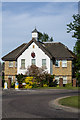
5
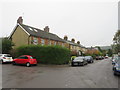
Dewlands, Godstone
Dewlands is a residential cul-de-sac in the village of Godstone, in Surrey.
Image: © Malc McDonald
Taken: 12 Oct 2019
0.08 miles
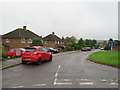
6
Crowhurst Mead
1990s development off London Road.
Image: © Ian Capper
Taken: 3 Jun 2013
0.08 miles
7
Crowhurst Mead
1990s development off Godstone Hill.
Image: © Ian Capper
Taken: 3 Jun 2013
0.08 miles
8
Salisbury Road
This road first appears, without development, on the 1896 1:2500 map. The flags commemorate this being Diamond Jubilee year.
Image: © Ian Capper
Taken: 19 Jun 2012
0.08 miles
9
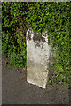
Milestone, Godstone Hill
Close up of the milestone in Image It dates from 1744 is one of a series of milestones on the Surrey and Sussex Turnpike of 1718, running from Southwark to Highgate in the Ashdown Forest, en route to Eastbourne. One side is inscribed "XX Miles From the Standard at Cornhill, LONDON - 1744" but the other inscriptions are unclear. Grade II listed - see http://www.historicengland.org.uk/listing/the-list/list-entry/1257943.
Image: © Ian Capper
Taken: 3 Jun 2013
0.09 miles
10
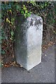
Old Milestone by the A25, High Street, Godstone
Carved stone post by the A25, in parish of GODSTONE (TANDRIDGE District), High Street, junction with Oxted Road (A25), on pavement, back to hedge, on East side of road. Surrey limestone pillar, erected by the Surrey & Sussex turnpike trust in the 18th century.
Inscription reads:-
: XX / Miles / from the / Standard / in / Cornhill / LONDON / 1744 : : XIX Miles / from / West / minster / Bridge : : XX / Miles / from the / Standard / in / Cornhill / LONDON / 1744 :
Carved benchmark and rivet on top.
Grade II listed. List Entry Number: 1257943
https://historicengland.org.uk/listing/the-list/list-entry/1257943
Milestone Society National ID: SY_LL20.
Image: © L Joseph & RS Payne
Taken: 1 May 2006
0.09 miles