IMAGES TAKEN NEAR TO
Tandridge Lane, OXTED, RH8 9NW
Introduction
This page details the photographs taken nearby to Tandridge Lane, RH8 9NW by members of the Geograph project.
The Geograph project started in 2005 with the aim of publishing, organising and preserving representative images for every square kilometre of Great Britain, Ireland and the Isle of Man.

There are currently over 7.5m images from over14,400 individuals and you can help contribute to the project by visiting https://www.geograph.org.uk
Image Map
Images are licensed for reuse under creativecommons.org/licenses/by-sa/2.0
Notes
- Clicking on the map will re-center to the selected point.
- The higher the marker number, the further away the image location is from the centre of the postcode.
Image Listing (7 Images Found)
Images are licensed for reuse under creativecommons.org/licenses/by-sa/2.0
Image
Details
Distance
1
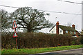
Oast House at Newhouse Farm, Tandridge Lane, Tandridge, Surrey
Image: © Oast House Archive
Taken: 23 Aug 2009
0.05 miles
3
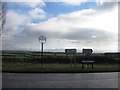
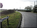
Approach to Tandridge Lane - Southlands Lane junction
The road sign shows the main route to bend to the right with a side road to the left. Tandridge Lane is in the foreground - it then turns left, and the main route bends right to become Southlands Lane. The junction has been remodelled at some time - formerly the side branch was to the right and Tandridge Lane was the through route.
Image: © Robin Webster
Taken: 24 Jan 2010
0.17 miles
4
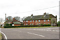
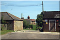
Cottages at the junction
Where Southlands Lane meets Tandridge Lane.
Image: © Robin Webster
Taken: 24 Jan 2010
0.20 miles