IMAGES TAKEN NEAR TO
High Street, OXTED, RH8 9LP
Introduction
This page details the photographs taken nearby to High Street, RH8 9LP by members of the Geograph project.
The Geograph project started in 2005 with the aim of publishing, organising and preserving representative images for every square kilometre of Great Britain, Ireland and the Isle of Man.

There are currently over 7.5m images from over14,400 individuals and you can help contribute to the project by visiting https://www.geograph.org.uk
Image Map (Loading...)


Getting Data...Please wait
Leaflet Map data © OpenStreetMap
Images are licensed for reuse under creativecommons.org/licenses/by-sa/2.0
Notes
- Clicking on the map will re-center to the selected point.
- The higher the marker number, the further away the image location is from the centre of the postcode.
Image Listing (62 Images Found)
Images are licensed for reuse under creativecommons.org/licenses/by-sa/2.0
Image
Details
Distance
2
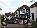
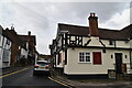
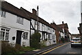
The Crown Inn, Old Oxted
Grade II listed public house on Old Oxted High Street.
See http://www.britishlistedbuildings.co.uk/en-287894-the-crown-inn-oxted for more details about the former converted cottages.
Image: © David Anstiss
Taken: 16 May 2012
0.01 miles
7
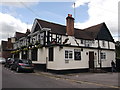
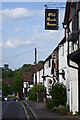
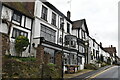
The George Public House, Old Oxted
On Old Oxted High Street.
Image: © David Anstiss
Taken: 16 May 2012
0.03 miles