IMAGES TAKEN NEAR TO
Ridlands Lane, OXTED, RH8 0TU
Introduction
This page details the photographs taken nearby to Ridlands Lane, RH8 0TU by members of the Geograph project.
The Geograph project started in 2005 with the aim of publishing, organising and preserving representative images for every square kilometre of Great Britain, Ireland and the Isle of Man.

There are currently over 7.5m images from over14,400 individuals and you can help contribute to the project by visiting https://www.geograph.org.uk
Image Map
Images are licensed for reuse under creativecommons.org/licenses/by-sa/2.0
Notes
- Clicking on the map will re-center to the selected point.
- The higher the marker number, the further away the image location is from the centre of the postcode.
Image Listing (8 Images Found)
Images are licensed for reuse under creativecommons.org/licenses/by-sa/2.0
Image
Details
Distance
1
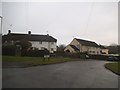
Marjorie Pease Cottages, Limpsfield Chart
Image: © David Howard
Taken: 8 Jan 2017
0.04 miles
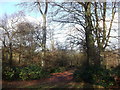
3
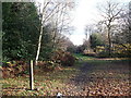
Path and bridleway junction in Limpsfield Common
A path leads straight on and around the woodland of the common.
The bridleway leads left through the common woodland towards Kent Hatch Road.
Image: © David Anstiss
Taken: 27 Nov 2011
0.21 miles
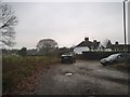
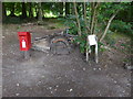
4
Limpsfield Common Car Park
One of two car parks for the common.
This one is on Ridlands Road (to the east of the common).
Image: © David Anstiss
Taken: 27 Nov 2011
0.22 miles
5
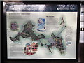
Limpsfield Common Information Board
Beside Image on Ridlands Lane.
Image: © David Anstiss
Taken: 27 Nov 2011
0.22 miles
6
London Countryway in Surrey (3)
How cute is that?
Image: © Shazz
Taken: 4 Jul 2017
0.24 miles
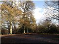
7
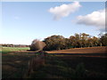
Footpath to Loampit Wood
A field edge path leads from Limpsfield Common towards the woodland (in the background) on Watts Hill.
Image: © David Anstiss
Taken: 27 Nov 2011
0.24 miles
8
Path in Limpsfield Common
This path leads from Loampit Wood, through the woodland of the common towards Kent Hatch Road.
Image: © David Anstiss
Taken: 27 Nov 2011
0.25 miles