IMAGES TAKEN NEAR TO
Westerham Road, OXTED, RH8 0SW
Introduction
This page details the photographs taken nearby to Westerham Road, RH8 0SW by members of the Geograph project.
The Geograph project started in 2005 with the aim of publishing, organising and preserving representative images for every square kilometre of Great Britain, Ireland and the Isle of Man.

There are currently over 7.5m images from over14,400 individuals and you can help contribute to the project by visiting https://www.geograph.org.uk
Image Map
Images are licensed for reuse under creativecommons.org/licenses/by-sa/2.0
Notes
- Clicking on the map will re-center to the selected point.
- The higher the marker number, the further away the image location is from the centre of the postcode.
Image Listing (12 Images Found)
Images are licensed for reuse under creativecommons.org/licenses/by-sa/2.0
Image
Details
Distance
1
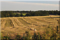
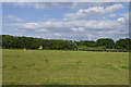
Tandridge : Grassy Field & Sheep
Looking out towards a grassy field with sheep grazing.
Image: © Lewis Clarke
Taken: 8 Aug 2015
0.06 miles
4
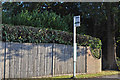
Tandridge : Westerham Road Bus Stop
A bus stop on Westerham Road.
Image: © Lewis Clarke
Taken: 8 Aug 2015
0.14 miles
6
The Greensand Way crosses the A25
The long distance path heads from Loampit Wood, up Watts Hill, then crosses Westerham Road, to take a track towards Broomlands Farm.
Image: © David Anstiss
Taken: 27 Nov 2011
0.16 miles
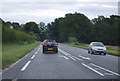
7

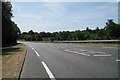
Westerham Road
The A15 east of Limpsfield.
Image: © Ian Capper
Taken: 1 Jul 2013
0.16 miles
9
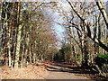
Broomlands Lane
This access track leads from Westerham Road, through Thrift Wood towards Brooklands Farm and then onwards to Titsey Wood and Titsey.
It is also used by the Greensand Way (and Vanguard Way) heading towards Titsey Place.
Image: © David Anstiss
Taken: 27 Nov 2011
0.21 miles
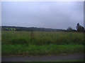
10
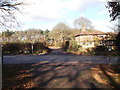
Field off Westerham Road
A field off Westerham Road, just visible to the right of the photo. The trees on the left are a screen for Moorhouse Sand Pits.
Image: © Ian Capper
Taken: 1 Jul 2013
0.24 miles