IMAGES TAKEN NEAR TO
Ballards Lane, OXTED, RH8 0SN
Introduction
This page details the photographs taken nearby to Ballards Lane, RH8 0SN by members of the Geograph project.
The Geograph project started in 2005 with the aim of publishing, organising and preserving representative images for every square kilometre of Great Britain, Ireland and the Isle of Man.

There are currently over 7.5m images from over14,400 individuals and you can help contribute to the project by visiting https://www.geograph.org.uk
Image Map
Images are licensed for reuse under creativecommons.org/licenses/by-sa/2.0
Notes
- Clicking on the map will re-center to the selected point.
- The higher the marker number, the further away the image location is from the centre of the postcode.
Image Listing (20 Images Found)
Images are licensed for reuse under creativecommons.org/licenses/by-sa/2.0
Image
Details
Distance
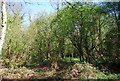
1
London Countryway in Surrey (4)
This is Kent Hatch Road (the B269) which is followed northwards for 200 yards or so.
Image: © Shazz
Taken: 4 Jul 2017
0.15 miles
3
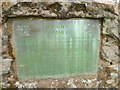
London Countryway in Surrey (6)
Here's the inscription on the stone seen at http://www.geograph.org.uk/photo/5461574.
Image: © Shazz
Taken: 4 Jul 2017
0.17 miles
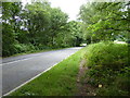
4
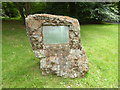
London Countryway in Surrey (5)
This stone commemorates the giving of land on Limpsfield Common to the National Trust. The inscription is shown at http://www.geograph.org.uk/photo/5461578.
Image: © Shazz
Taken: 4 Jul 2017
0.17 miles
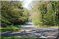
7
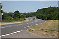
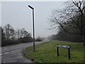
A25, Westerham Road
Towards Westerham.
Image: © Oast House Archive
Taken: 9 Jul 2010
0.22 miles
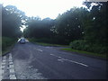
8
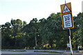
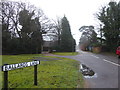
Tandridge : Grub Street
Looking along Grub Street from Westerham Road.
Image: © Lewis Clarke
Taken: 8 Aug 2015
0.22 miles