IMAGES TAKEN NEAR TO
Evelyn Avenue, Pilgrims Lane, OXTED, RH8 0SF
Introduction
This page details the photographs taken nearby to Evelyn Avenue, Pilgrims Lane, RH8 0SF by members of the Geograph project.
The Geograph project started in 2005 with the aim of publishing, organising and preserving representative images for every square kilometre of Great Britain, Ireland and the Isle of Man.

There are currently over 7.5m images from over14,400 individuals and you can help contribute to the project by visiting https://www.geograph.org.uk
Image Map
Images are licensed for reuse under creativecommons.org/licenses/by-sa/2.0
Notes
- Clicking on the map will re-center to the selected point.
- The higher the marker number, the further away the image location is from the centre of the postcode.
Image Listing (87 Images Found)
Images are licensed for reuse under creativecommons.org/licenses/by-sa/2.0
Image
Details
Distance
1
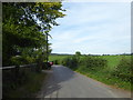
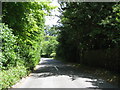
Looking east along Pilgrims' Way
This is taken from alongside Evelyn Avenue on a warm summer's evening.
Image: © Marathon
Taken: 28 Aug 2017
0.03 miles
2
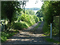
Track south from Pilgrims Lane, Titsey
Also the start of a long public bridleway to Limpsfield Chart.
Image: © Robin Webster
Taken: 31 Jul 2011
0.05 miles
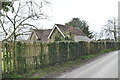
8
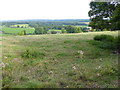
View from White Lane
White Lane is steep and narrow as it heads up on to the North Downs. In one or two places it gives views back across the M25 towards Limpsfield Chart and Crockhamhill Common.
Image: © Marathon
Taken: 28 Aug 2017
0.10 miles
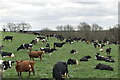
10
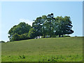
Tree clump, slopes of Titsey Hill
Above the church.
Image: © Robin Webster
Taken: 31 Jul 2011
0.12 miles