IMAGES TAKEN NEAR TO
Water Lane, OXTED, RH8 0SA
Introduction
This page details the photographs taken nearby to Water Lane, RH8 0SA by members of the Geograph project.
The Geograph project started in 2005 with the aim of publishing, organising and preserving representative images for every square kilometre of Great Britain, Ireland and the Isle of Man.

There are currently over 7.5m images from over14,400 individuals and you can help contribute to the project by visiting https://www.geograph.org.uk
Image Map
Images are licensed for reuse under creativecommons.org/licenses/by-sa/2.0
Notes
- Clicking on the map will re-center to the selected point.
- The higher the marker number, the further away the image location is from the centre of the postcode.
Image Listing (45 Images Found)
Images are licensed for reuse under creativecommons.org/licenses/by-sa/2.0
Image
Details
Distance
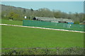
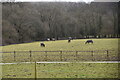
6
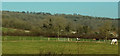
Grazing near Park Farm
Looking more to the right than Image], with Limpsfield Lodge Farm behind the dead tree.
Image: © Derek Harper
Taken: 23 Feb 2019
0.08 miles
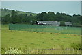
7
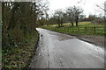
Towards the M25
Water Lane, to the north of Limpsfield.
Image: © Peter Trimming
Taken: 2 Feb 2023
0.08 miles
8
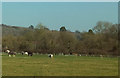
Grazing near Park Farm
Looking more to the right than Image
Image: © Derek Harper
Taken: 23 Feb 2019
0.10 miles
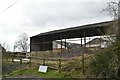
10
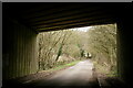
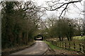
Under the M25
Water Lane, north of Limpsfield.
Image: © Peter Trimming
Taken: 2 Feb 2023
0.12 miles