IMAGES TAKEN NEAR TO
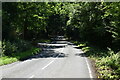
Red Lane, OXTED, RH8 0RT
Introduction
This page details the photographs taken nearby to Red Lane, RH8 0RT by members of the Geograph project.
The Geograph project started in 2005 with the aim of publishing, organising and preserving representative images for every square kilometre of Great Britain, Ireland and the Isle of Man.

There are currently over 7.5m images from over14,400 individuals and you can help contribute to the project by visiting https://www.geograph.org.uk
Image Map
Images are licensed for reuse under creativecommons.org/licenses/by-sa/2.0
Notes
- Clicking on the map will re-center to the selected point.
- The higher the marker number, the further away the image location is from the centre of the postcode.
Image Listing (32 Images Found)
Images are licensed for reuse under creativecommons.org/licenses/by-sa/2.0
Image
Details
Distance
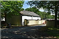
2
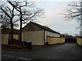
The rear of Connerton Stables on Red Lane
Image: © David Howard
Taken: 25 Jan 2015
0.03 miles
5
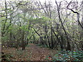
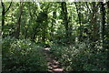
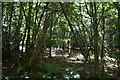
Footpath in Homesland Wood
A path leads from Red Lane through the wood towards Hillview Farm on Grants Lane.
Image: © David Anstiss
Taken: 27 Nov 2011
0.07 miles