IMAGES TAKEN NEAR TO
Grants Lane, OXTED, RH8 0RH
Introduction
This page details the photographs taken nearby to Grants Lane, RH8 0RH by members of the Geograph project.
The Geograph project started in 2005 with the aim of publishing, organising and preserving representative images for every square kilometre of Great Britain, Ireland and the Isle of Man.

There are currently over 7.5m images from over14,400 individuals and you can help contribute to the project by visiting https://www.geograph.org.uk
Image Map
Images are licensed for reuse under creativecommons.org/licenses/by-sa/2.0
Notes
- Clicking on the map will re-center to the selected point.
- The higher the marker number, the further away the image location is from the centre of the postcode.
Image Listing (52 Images Found)
Images are licensed for reuse under creativecommons.org/licenses/by-sa/2.0
Image
Details
Distance
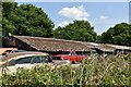
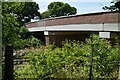
3
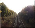
Railway to Edenbridge
As seen from Image
This line leads from Hurst Green, through Collesters Wood to Edenbridge.
Image: © David Anstiss
Taken: 27 Nov 2011
0.03 miles
7
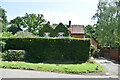
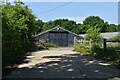
Path beside Hillview Farm
A path leads from Grants Lane, past the farm towards Honesland Wood (in the background) and onwards to Red Lane.
Image: © David Anstiss
Taken: 27 Nov 2011
0.06 miles
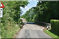
9
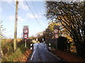
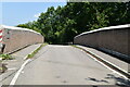
Grants Lane railway bridge
This lane leads from Staffhurst Wood to Hurst Green.
It passes over the railway between Hurst Green and Edenbridge.
See Image
Image: © David Anstiss
Taken: 27 Nov 2011
0.06 miles