IMAGES TAKEN NEAR TO
Chalkpit Lane, OXTED, RH8 0QW
Introduction
This page details the photographs taken nearby to Chalkpit Lane, RH8 0QW by members of the Geograph project.
The Geograph project started in 2005 with the aim of publishing, organising and preserving representative images for every square kilometre of Great Britain, Ireland and the Isle of Man.

There are currently over 7.5m images from over14,400 individuals and you can help contribute to the project by visiting https://www.geograph.org.uk
Image Map
Images are licensed for reuse under creativecommons.org/licenses/by-sa/2.0
Notes
- Clicking on the map will re-center to the selected point.
- The higher the marker number, the further away the image location is from the centre of the postcode.
Image Listing (60 Images Found)
Images are licensed for reuse under creativecommons.org/licenses/by-sa/2.0
Image
Details
Distance
1
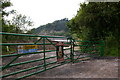
Entrance to Oxted Quarry
The quarry is now being developed as a landfill site.
Image: © Ian Capper
Taken: 9 Jun 2008
0.02 miles
2
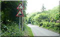
Chalkpit Lane - Steep Hill 20%
Chalkpit Lane, Oxted. 20% steep hill up sign.
Image: © Adam Morse
Taken: 11 Jun 2009
0.03 miles
3
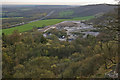
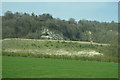
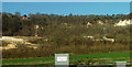
Oxted Quarry
Looking down on this chalk quarry quarry from above, with the M25 beyond.
Image: © Ian Capper
Taken: 15 Apr 2010
0.03 miles
4
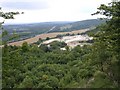
Oxted Quarry
A former chalk quarry, now used for processing recovered demolition rubble and the like.
Image: © Robin Webster
Taken: 18 Jan 2011
0.04 miles
5
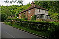
Cottages, Chalkpit Lane, Oxted
Former quarryworkers cottages for the nearby Oxted Quarry.
Image: © Ian Capper
Taken: 9 Jun 2008
0.05 miles
7
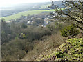
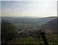
Quarry, looking down from the top
Looking down from the edge of the quarry that occupies much of this square.
Image: © Hywel Williams
Taken: 1 Sep 2005
0.10 miles
8
Mind the edge!
The cliff formed by the quarry below eating into the North Downs.
A busy M25 in the distance.
Image: © Russel Wills
Taken: 13 Mar 2014
0.11 miles
9
Oxted Quarry
From a little further ENE along the M25 from Image The houses at top left are on The Ridge. The Pilgrims' Way and North Downs Way cross the image below the quarry.
Image: © Derek Harper
Taken: 23 Feb 2019
0.12 miles
10
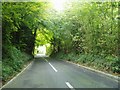
Narrow steep road past the quarry
The road allows you to descend from the north Downs at Woldingham to Oxted
Image: © Nigel Freeman
Taken: 25 Sep 2005
0.12 miles