IMAGES TAKEN NEAR TO
Station Road East, OXTED, RH8 0QE
Introduction
This page details the photographs taken nearby to Station Road East, RH8 0QE by members of the Geograph project.
The Geograph project started in 2005 with the aim of publishing, organising and preserving representative images for every square kilometre of Great Britain, Ireland and the Isle of Man.

There are currently over 7.5m images from over14,400 individuals and you can help contribute to the project by visiting https://www.geograph.org.uk
Image Map
Images are licensed for reuse under creativecommons.org/licenses/by-sa/2.0
Notes
- Clicking on the map will re-center to the selected point.
- The higher the marker number, the further away the image location is from the centre of the postcode.
Image Listing (167 Images Found)
Images are licensed for reuse under creativecommons.org/licenses/by-sa/2.0
Image
Details
Distance
1
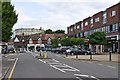
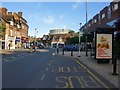
Station Road East
Part of Oxted's main shopping street. In the background is the gasholder that is a significant part of the townscape.
Image: © Ian Capper
Taken: 3 Jul 2013
0.02 miles
2
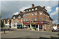
Station Road East
Part of Oxted's main shopping street.
Image: © Ian Capper
Taken: 3 Jul 2013
0.02 miles
4
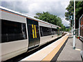
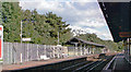
Southbound Platform, Oxted Station, Surrey
Looking north. A train from London Victoria is just departing.
Image: © Christine Matthews
Taken: 19 Jun 2010
0.03 miles
5
Oxted: the main drag
Looking south-east from outside Pizza Express. There's less mock-Tudor along this stretch than elsewhere. And look at the gas-holder: somebody had the cheek to mock Oxted's mock-Tudor, by plonking that down there. On the left, in the sunshine: Image
Image: © Stefan Czapski
Taken: 6 Jun 2010
0.03 miles
6
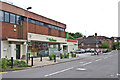
Sainsbury's Local, Oxted
On the corner of Station Road East and Amy Road.
Image: © Robin Webster
Taken: 6 Oct 2019
0.04 miles
7
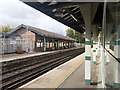
Oxted Station
View SE, towards East Grinstead and Uckfield: ex-LB&SCR (Joint with SE&CR East Croydon - Groombridge) London (Victoria/London Bridge) - East Croydon - Oxted - East Grinstead - Lewes - (Brighton) (closed south of East Grinstead 3/58)/Oxted - Groombridge - Tunbridge Wells West/Eridge - Uckfield - Lewes - (Brighton) (closed south of Uckfield 1/69)/Eridge - Hailsham - Polegate - (Eastbourne) (closed Eridge - Hailsham 6/65, Hailsham - Polegate 9/68).
Image: © Ben Brooksbank
Taken: 21 Aug 2004
0.04 miles
8
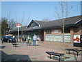
Oxted station, up platform building
Looking from the down platform.
Image: © Robin Webster
Taken: 6 Oct 2019
0.04 miles
9
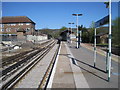
Oxted railway station, Surrey
Opened in 1884 by the London Brighton & South Coast Railway on what is now the line from Croydon to Uckfield. View north west towards Woldingham and Croydon.
Image: © Nigel Thompson
Taken: 9 Apr 2011
0.04 miles
10
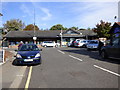
Oxted Station
Good train services but hardly anywhere to park your car.
Image: © Dr Neil Clifton
Taken: 7 Oct 2014
0.04 miles