IMAGES TAKEN NEAR TO
Station Road East, OXTED, RH8 0PJ
Introduction
This page details the photographs taken nearby to Station Road East, RH8 0PJ by members of the Geograph project.
The Geograph project started in 2005 with the aim of publishing, organising and preserving representative images for every square kilometre of Great Britain, Ireland and the Isle of Man.

There are currently over 7.5m images from over14,400 individuals and you can help contribute to the project by visiting https://www.geograph.org.uk
Image Map (Loading...)


Getting Data...Please wait
Leaflet Map data © OpenStreetMap
Images are licensed for reuse under creativecommons.org/licenses/by-sa/2.0
Notes
- Clicking on the map will re-center to the selected point.
- The higher the marker number, the further away the image location is from the centre of the postcode.
Image Listing (134 Images Found)
Images are licensed for reuse under creativecommons.org/licenses/by-sa/2.0
Image
Details
Distance
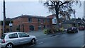
2
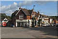
Sainsbury's Local, Oxted, Surrey
With daylight fading, the shop lighting starts to shine brightly. Located on Station Road East.
Image: © Peter Trimming
Taken: 18 Sep 2010
0.04 miles
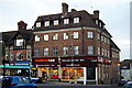
3
Sainsbury's Local, Oxted
On the corner of Station Road East and Amy Road.
Image: © Robin Webster
Taken: 6 Oct 2019
0.04 miles
4
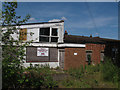
Derelict building on Amy Road
The original use of this derelict building was not clear, but the site was for sale and I expect the building would soon be demolished.
Image: © Stephen Craven
Taken: 26 May 2013
0.05 miles
5
Fennies Day Nursery
Fennies Day Nursery in Amy Road as it is now (and as it was then in May 2013, before re-development see http://www.geograph.org.uk/photo/3485596)
Image: © Marvin653
Taken: 11 Dec 2021
0.05 miles
6
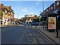
Oxted: the main drag
Looking south-east from outside Pizza Express. There's less mock-Tudor along this stretch than elsewhere. And look at the gas-holder: somebody had the cheek to mock Oxted's mock-Tudor, by plonking that down there. On the left, in the sunshine: Image
Image: © Stefan Czapski
Taken: 6 Jun 2010
0.05 miles
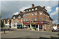
7
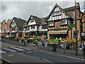
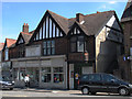
Shops and restaurants, Station Road East, Oxted
Nothing is really old here in what was first called New Oxted, the whole settlement here was created when the railway came (quite late - 1884) and was just built to look old.
Image: © Robin Webster
Taken: 6 Oct 2019
0.05 miles
8
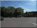
Amy Road car park
The car park was nearly empty at 2pm on a Sunday, reflecting the fact that unlike most towns, few shops in Oxted are open on a Sunday.
Image: © Stephen Craven
Taken: 26 May 2013
0.06 miles
9
Former grocer's shop
This shop just outside Oxted station is now a Nepalese restaurant, but a ghost sign "Cooper Family Grocer Provisions" gives away its original use. There are other words but not legible in this view.
Image: © Stephen Craven
Taken: 26 May 2013
0.06 miles
10
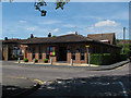
The Kings Church, Amy Road
A contemporary style church/community building near the centre of Oxted.
Image: © Stephen Craven
Taken: 26 May 2013
0.06 miles