IMAGES TAKEN NEAR TO
Rockfield Road, OXTED, RH8 0HA
Introduction
This page details the photographs taken nearby to Rockfield Road, RH8 0HA by members of the Geograph project.
The Geograph project started in 2005 with the aim of publishing, organising and preserving representative images for every square kilometre of Great Britain, Ireland and the Isle of Man.

There are currently over 7.5m images from over14,400 individuals and you can help contribute to the project by visiting https://www.geograph.org.uk
Image Map
Images are licensed for reuse under creativecommons.org/licenses/by-sa/2.0
Notes
- Clicking on the map will re-center to the selected point.
- The higher the marker number, the further away the image location is from the centre of the postcode.
Image Listing (23 Images Found)
Images are licensed for reuse under creativecommons.org/licenses/by-sa/2.0
Image
Details
Distance
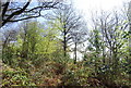
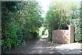
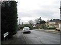
3
London Countryway in Surrey (27)
A footpath joins from the left.
Image: © Shazz
Taken: 16 Aug 2017
0.04 miles
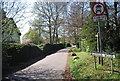
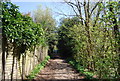
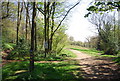
7
London Countryway in Surrey (28)
Rockfield Road is reached and crossed and the Way enters Icehouse Wood.
Image: © Shazz
Taken: 16 Aug 2017
0.05 miles
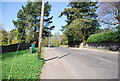
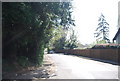
9
Greensand Way entering Limpsfield Common
Image: © N Chadwick
Taken: 10 Apr 2011
0.08 miles