IMAGES TAKEN NEAR TO
Brassey Road, OXTED, RH8 0ET
Introduction
This page details the photographs taken nearby to Brassey Road, RH8 0ET by members of the Geograph project.
The Geograph project started in 2005 with the aim of publishing, organising and preserving representative images for every square kilometre of Great Britain, Ireland and the Isle of Man.

There are currently over 7.5m images from over14,400 individuals and you can help contribute to the project by visiting https://www.geograph.org.uk
Image Map (Loading...)


Getting Data...Please wait
Leaflet Map data © OpenStreetMap
Images are licensed for reuse under creativecommons.org/licenses/by-sa/2.0
Notes
- Clicking on the map will re-center to the selected point.
- The higher the marker number, the further away the image location is from the centre of the postcode.
Image Listing (17 Images Found)
Images are licensed for reuse under creativecommons.org/licenses/by-sa/2.0
Image
Details
Distance
1
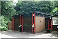
Oxted fire station
Oxted fire station, Potters Sandpit, Oxted, Surrey is easily missed travelling along East Hill - it is tucked away up a small lane.
Image: © Kevin Hale
Taken: 17 Jun 2007
0.05 miles
2
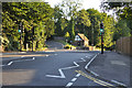
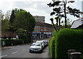
Limpsfield : East Hill A25
Looking along East Hill in Limpsfield.
Image: © Lewis Clarke
Taken: 8 Aug 2015
0.12 miles
3
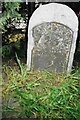
Old Milestone, A25, Westerham Road, outside no.49
The milestone is located on the north side of the road on the pavement under the hedge between the lamp post and the drive to No 49 Westerham Road. Parish of Limpsfield (Tandridge district). Metal plate attached to stone post, Wrotham iron plate design, erected by the Wrotham Heath turnpike trust in the 19th century.
Inscription reads:- MAIDSTONE / 25 / GODSTONE / 4
Milestone Society National ID: SY_MDGS25
Image: © John Payne
Taken: Unknown
0.14 miles
5

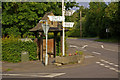
Direction Sign - Signpost on the A25 Westerham Road, Limpsfield
Spear & ball finial - 3 arms; Surrey Spear by the A25, in parish of Limpsfield (Tandridge District), Westerham Road, junction with Detillens Lane (B2025), village centre, by derelict drinking fountain.
Surveyed
Milestone Society National ID: SY_TQ4052
Image: © C Woodward
Taken: 20 Jun 2009
0.15 miles
6
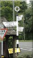
Direction Sign - Signpost on the A25 Westerham Road, Limpsfield
Located between a drinking fountain and a horse trough on the northeast side of the junction of the A25 Westerham Road and the B2025 Detillens Lane in Limpsfield parish. 3 arms and annulus finial. The annulus replaced a ball and spear finial which can be seen on the 2009 photo https://www.geograph.org.uk/photo/6068664.
Milestone Society National ID: SY_TQ4052
Image: © I Clare
Taken: Unknown
0.15 miles
7
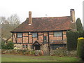
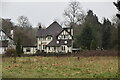
Burnside House
On the A25 Westerham Road, near to the junction with Detillens Lane
Image: © David Anstiss
Taken: 13 Mar 2010
0.16 miles
8
Drinking trough and fountain
At the junction of Detillens Lane with the A25. At the end facing the camera the trough is inscribed "Drinking Fountain and Cattle Trough Association 70 Victoria Street SW" (i.e. without the "Metropolitan" that normal is included in the association's title on such troughs). On the rear of trough, and also around the drinking fountain (in the shelter) is inscribed "Presented by Alice and Horace Barry 1913", who were longstanding residents of Home Place in nearby Oxted.
Image: © Ian Capper
Taken: 26 Jun 2008
0.17 miles
9
Snatts Hill, Oxted
Looking towards the centre of Oxted, and the old gas holder.
Image: © Peter Trimming
Taken: 13 May 2015
0.21 miles