IMAGES TAKEN NEAR TO
Padbrook, OXTED, RH8 0DZ
Introduction
This page details the photographs taken nearby to Padbrook, RH8 0DZ by members of the Geograph project.
The Geograph project started in 2005 with the aim of publishing, organising and preserving representative images for every square kilometre of Great Britain, Ireland and the Isle of Man.

There are currently over 7.5m images from over14,400 individuals and you can help contribute to the project by visiting https://www.geograph.org.uk
Image Map
Images are licensed for reuse under creativecommons.org/licenses/by-sa/2.0
Notes
- Clicking on the map will re-center to the selected point.
- The higher the marker number, the further away the image location is from the centre of the postcode.
Image Listing (91 Images Found)
Images are licensed for reuse under creativecommons.org/licenses/by-sa/2.0
Image
Details
Distance
1
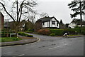
Padbrook, Limpsfield
The roads and verges on this small housing estate are so well kept that I presume it is either privately managed, or has a very active residents' association.
Image: © Stephen Craven
Taken: 26 May 2013
0.04 miles
6
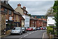
The Bull at Limpsfield
An early 16th century coaching Inn and now a very popular pub serving the beautiful village of Limpsfield
Image: © Nigel Freeman
Taken: 22 Aug 2005
0.12 miles
8
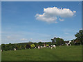
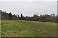
Cows on a footpath near Oxted
It is hard to believe that this pastoral scene is so close to the urban centre of Oxted.
Image: © Stephen Craven
Taken: 26 May 2013
0.15 miles