IMAGES TAKEN NEAR TO
Hookwood Corner, OXTED, RH8 0DL
Introduction
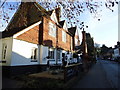
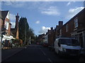
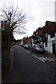
This page details the photographs taken nearby to Hookwood Corner, RH8 0DL by members of the Geograph project.
The Geograph project started in 2005 with the aim of publishing, organising and preserving representative images for every square kilometre of Great Britain, Ireland and the Isle of Man.

There are currently over 7.5m images from over14,400 individuals and you can help contribute to the project by visiting https://www.geograph.org.uk
Image Map
Images are licensed for reuse under creativecommons.org/licenses/by-sa/2.0
Notes
- Clicking on the map will re-center to the selected point.
- The higher the marker number, the further away the image location is from the centre of the postcode.
Image Listing (184 Images Found)
Images are licensed for reuse under creativecommons.org/licenses/by-sa/2.0
Image
Details
Distance
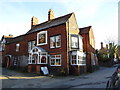
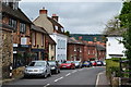
3
The Bull, Limpsfield
On High Street.
Grade II listed http://list.english-heritage.org.uk/resultsingle.aspx?uid=1294532
Image: © Oast House Archive
Taken: 28 Jul 2010
0.06 miles

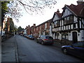
10
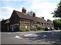
Corner of Detillens Lane, Limpsfield
The building on the corner, Detillens Cottage, is listed grade 2* (list entry number 1377656).
Image: © Stephen Craven
Taken: 26 May 2013
0.09 miles