IMAGES TAKEN NEAR TO
Bluehouse Lane, OXTED, RH8 0AP
Introduction
This page details the photographs taken nearby to Bluehouse Lane, RH8 0AP by members of the Geograph project.
The Geograph project started in 2005 with the aim of publishing, organising and preserving representative images for every square kilometre of Great Britain, Ireland and the Isle of Man.

There are currently over 7.5m images from over14,400 individuals and you can help contribute to the project by visiting https://www.geograph.org.uk
Image Map
Images are licensed for reuse under creativecommons.org/licenses/by-sa/2.0
Notes
- Clicking on the map will re-center to the selected point.
- The higher the marker number, the further away the image location is from the centre of the postcode.
Image Listing (18 Images Found)
Images are licensed for reuse under creativecommons.org/licenses/by-sa/2.0
Image
Details
Distance
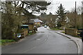
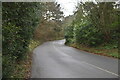
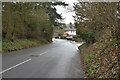
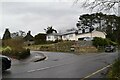
2
Limpsfield
The junction of Water Lane with Bluehouse Lane.
Image: © Peter Trimming
Taken: 2 Feb 2023
0.17 miles
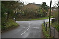
6
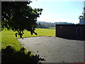
Limpsfield Blues - The Glebe fields beyond
Limpsfield Blues play football here and their pitch is surrounded by the Glebe fields
Image: © Steve Hurley
Taken: 3 Nov 2006
0.19 miles
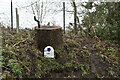
8
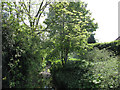
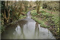
River Eden at Limpsfield
The watercourse hardly deserves the name of "River" at this point.
Image: © Stephen Craven
Taken: 26 May 2013
0.21 miles