IMAGES TAKEN NEAR TO
Bluehouse Lane, OXTED, RH8 0AB
Introduction
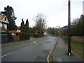
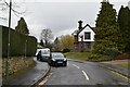
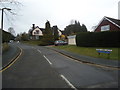
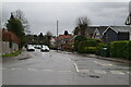
This page details the photographs taken nearby to Bluehouse Lane, RH8 0AB by members of the Geograph project.
The Geograph project started in 2005 with the aim of publishing, organising and preserving representative images for every square kilometre of Great Britain, Ireland and the Isle of Man.

There are currently over 7.5m images from over14,400 individuals and you can help contribute to the project by visiting https://www.geograph.org.uk
Image Map
Images are licensed for reuse under creativecommons.org/licenses/by-sa/2.0
Notes
- Clicking on the map will re-center to the selected point.
- The higher the marker number, the further away the image location is from the centre of the postcode.
Image Listing (87 Images Found)
Images are licensed for reuse under creativecommons.org/licenses/by-sa/2.0
Image
Details
Distance
3

86 Bluehouse Lane
86 Bluehouse Lane, Oxted in course of demolition as part of site re-development
Image: © Marvin653
Taken: 10 Dec 2021
0.04 miles
6
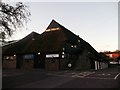
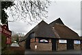
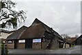
Barn Theatre, Oxted
Converted large wooden farm barn into a community theatre on Bluehouse Lane.
Image: © David Anstiss
Taken: 27 Nov 2011
0.05 miles