IMAGES TAKEN NEAR TO
The Platt, LINGFIELD, RH7 6QZ
Introduction
This page details the photographs taken nearby to The Platt, RH7 6QZ by members of the Geograph project.
The Geograph project started in 2005 with the aim of publishing, organising and preserving representative images for every square kilometre of Great Britain, Ireland and the Isle of Man.

There are currently over 7.5m images from over14,400 individuals and you can help contribute to the project by visiting https://www.geograph.org.uk
Image Map
Images are licensed for reuse under creativecommons.org/licenses/by-sa/2.0
Notes
- Clicking on the map will re-center to the selected point.
- The higher the marker number, the further away the image location is from the centre of the postcode.
Image Listing (49 Images Found)
Images are licensed for reuse under creativecommons.org/licenses/by-sa/2.0
Image
Details
Distance
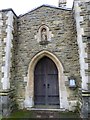
1
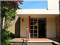
St John's church: entrance to the Centenary Room
See Shared description for more detail.
Image: © Stephen Craven
Taken: 4 May 2011
0.03 miles
2
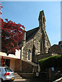
St John's church: south end
The liturgical west / geographical south end of the church, with a small bellcote.
Image: © Stephen Craven
Taken: 4 May 2011
0.03 miles
3
St John, Dormansland: mid December 2015
Image: © Basher Eyre
Taken: 19 Dec 2015
0.04 miles
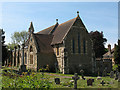
4
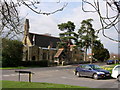
The Parish Church of St. John - Dormansland - Surrey
The church was built in 1882 as a chapel of ease to nearby Lingfield, but became a parish in its own right soon after.
Image: © Jean Barrow
Taken: 18 Apr 2006
0.04 miles
7
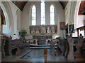
Chancel of St John's church
A typical late Victorian chancel, with the floor, communion rail, holy table and reredos all in stone (probably marble or alabaster) and wooden choir stalls in collegiate style.
Image: © Stephen Craven
Taken: 4 May 2011
0.05 miles
8
St John's church - north end
The liturgical east end of the church, which actually faces nearly north (parallel to Dormans High Street).
Image: © Stephen Craven
Taken: 4 May 2011
0.05 miles
9
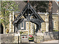
St John's church: lychgate
This is not strictly a "lychgate" (place for resting a coffin), more a 19th century reproduction of a mediaeval idea, but covered churchyard entrances like this are usually referred to as such.
Image: © Stephen Craven
Taken: 4 May 2011
0.05 miles
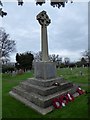
10
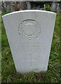
St John, Dormansland: churchyard (iii)
For more information see http://www.cwgc.org/find-war-dead/casualty/400443/SAUNDERS,%20JOHN%20HENRY
Image: © Basher Eyre
Taken: 19 Dec 2015
0.05 miles