IMAGES TAKEN NEAR TO
Newhache, LINGFIELD, RH7 6PX
Introduction
This page details the photographs taken nearby to Newhache, RH7 6PX by members of the Geograph project.
The Geograph project started in 2005 with the aim of publishing, organising and preserving representative images for every square kilometre of Great Britain, Ireland and the Isle of Man.

There are currently over 7.5m images from over14,400 individuals and you can help contribute to the project by visiting https://www.geograph.org.uk
Image Map
Images are licensed for reuse under creativecommons.org/licenses/by-sa/2.0
Notes
- Clicking on the map will re-center to the selected point.
- The higher the marker number, the further away the image location is from the centre of the postcode.
Image Listing (36 Images Found)
Images are licensed for reuse under creativecommons.org/licenses/by-sa/2.0
Image
Details
Distance
1
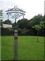
Dormansland Village Sign
On a small green, at the junction of Newhache and Dormans High Street.
Image: © David Anstiss
Taken: 10 Jul 2011
0.05 miles
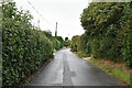
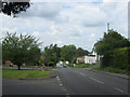
2
Plough Road at the junction of Dormans Road
Image: © David Howard
Taken: 20 Sep 2015
0.08 miles
3
Dormansland Baptist Church
Just off Dormans High Street.
Image: © David Anstiss
Taken: 10 Jul 2011
0.08 miles
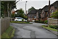
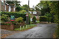
4
Crossroads in Dormansland
Dormans High Street, leads straight on as Plough Road.
Hollow Lane leads right to Gotwick.
Dormans Road leads left towards Lingfield.
Image: © David Anstiss
Taken: 10 Jul 2011
0.08 miles
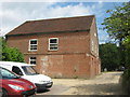
6
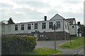
Dormansland Memorial Hall
On the junction of Plough Road (on the right) and Hollow Lane (behind the hall).
Image: © David Anstiss
Taken: 10 Jul 2011
0.10 miles
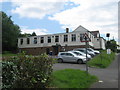
8
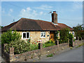
Lothlorien
A pair of picturesque stone cottages on West Street, Dormansland
Image: © Richard Croft
Taken: 28 Jun 2011
0.12 miles