IMAGES TAKEN NEAR TO
Racecourse Road, LINGFIELD, RH7 6PH
Introduction
This page details the photographs taken nearby to Racecourse Road, RH7 6PH by members of the Geograph project.
The Geograph project started in 2005 with the aim of publishing, organising and preserving representative images for every square kilometre of Great Britain, Ireland and the Isle of Man.

There are currently over 7.5m images from over14,400 individuals and you can help contribute to the project by visiting https://www.geograph.org.uk
Image Map
Images are licensed for reuse under creativecommons.org/licenses/by-sa/2.0
Notes
- Clicking on the map will re-center to the selected point.
- The higher the marker number, the further away the image location is from the centre of the postcode.
Image Listing (20 Images Found)
Images are licensed for reuse under creativecommons.org/licenses/by-sa/2.0
Image
Details
Distance
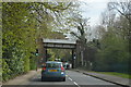
1
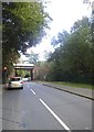
Railway bridge on Town Hill, Lingfield
Image: © David Howard
Taken: 20 Sep 2015
0.07 miles
5
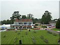
Lingfield Park
Course-side buildings at Lingfield Park
Image: © Richard Croft
Taken: 28 Jun 2011
0.14 miles
6
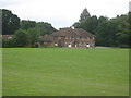
Sports Field and Building of Nostra Dame School
As seen from a footpath from Park Farm towards St.Piers Lane.
Image: © David Anstiss
Taken: 10 Jul 2011
0.14 miles
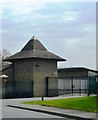
8
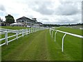
The Grandstand, Lingfield Racecourse
Image: © Roger Cornfoot
Taken: 16 Jun 2024
0.17 miles
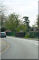
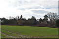
9
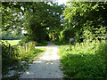
Mill Lane
Bridleway by the golf course at Lingfield
Image: © Richard Croft
Taken: 28 Jun 2011
0.18 miles
10
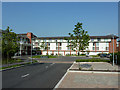
Lingfield Park Marriott Hotel
Hotel and Country Club by the racecourse http://www.marriott.co.uk/hotels/travel/lgwgs-lingfield-park-marriott-hotel-and-country-club/
Image: © Richard Croft
Taken: 28 Jun 2011
0.19 miles