IMAGES TAKEN NEAR TO
Hollow Lane, LINGFIELD, RH7 6PB
Introduction
This page details the photographs taken nearby to Hollow Lane, RH7 6PB by members of the Geograph project.
The Geograph project started in 2005 with the aim of publishing, organising and preserving representative images for every square kilometre of Great Britain, Ireland and the Isle of Man.

There are currently over 7.5m images from over14,400 individuals and you can help contribute to the project by visiting https://www.geograph.org.uk
Image Map
Images are licensed for reuse under creativecommons.org/licenses/by-sa/2.0
Notes
- Clicking on the map will re-center to the selected point.
- The higher the marker number, the further away the image location is from the centre of the postcode.
Image Listing (14 Images Found)
Images are licensed for reuse under creativecommons.org/licenses/by-sa/2.0
Image
Details
Distance
1
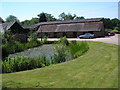
Lily Pond and stable block, Ladycross Farm, Hollow Lane, Dormansland, Surrey
Ladycross Farm seems to be trying to reinvent itself as a business park, with office and workshop units to let. With plenty of parking and a healthy environment for staff, it could well become very successful.
Image: © Dr Neil Clifton
Taken: 1 Jul 2006
0.01 miles
2
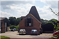
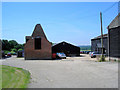
The Oast House, Lady Cross Business Park, Hollow Lane, Dormansland, Surrey
Single square kiln oast house, missing cowl. Now used as offices as part of the business park.
Image: © Oast House Archive
Taken: 16 Jul 2009
0.01 miles

5
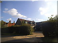
Ladycross Farm, near Dormansland, Surrey
See Image
Image: © Dr Neil Clifton
Taken: 1 Jul 2006
0.04 miles
10
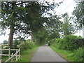
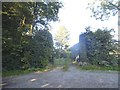
Moon's Lane near Burnpit Wood
A track (and bridleway) leads from Hollow Lane, past Little Redwood cottage and towards Burn Pit Farm.
It crosses another footpath, heading right to Upper Stonehurst Farm, or left via a gate towards Hollow Lane.
Image: © David Anstiss
Taken: 10 Jul 2011
0.19 miles