IMAGES TAKEN NEAR TO
Ford Manor Road, LINGFIELD, RH7 6NZ
Introduction
This page details the photographs taken nearby to Ford Manor Road, RH7 6NZ by members of the Geograph project.
The Geograph project started in 2005 with the aim of publishing, organising and preserving representative images for every square kilometre of Great Britain, Ireland and the Isle of Man.

There are currently over 7.5m images from over14,400 individuals and you can help contribute to the project by visiting https://www.geograph.org.uk
Image Map
Images are licensed for reuse under creativecommons.org/licenses/by-sa/2.0
Notes
- Clicking on the map will re-center to the selected point.
- The higher the marker number, the further away the image location is from the centre of the postcode.
Image Listing (32 Images Found)
Images are licensed for reuse under creativecommons.org/licenses/by-sa/2.0
Image
Details
Distance
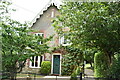
1
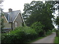
North Lodge, Greathed Manor
At the end of Dairy Farm track, which (then past the gates) becomes Ford Manor Road towards Lingfield.
Image: © David Anstiss
Taken: 10 Jul 2011
0.00 miles
5
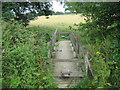
Footbridge near North Lodge
This footbridge is on a footpath from Dormansland to Moors Lane.
It passes over a stream leading (left) from St.John's Wood towards Eden Brook.
Image: © David Anstiss
Taken: 10 Jul 2011
0.04 miles
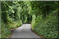
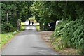
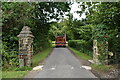
10
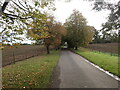
Ford manor Road
This attractive tree-lined driveway leads to Greathed Manor and to a variety of footpaths.
Image: © Marathon
Taken: 13 Oct 2024
0.09 miles