IMAGES TAKEN NEAR TO
Hollow Lane, LINGFIELD, RH7 6NS
Introduction
This page details the photographs taken nearby to Hollow Lane, RH7 6NS by members of the Geograph project.
The Geograph project started in 2005 with the aim of publishing, organising and preserving representative images for every square kilometre of Great Britain, Ireland and the Isle of Man.

There are currently over 7.5m images from over14,400 individuals and you can help contribute to the project by visiting https://www.geograph.org.uk
Image Map (Loading...)


Getting Data...Please wait
Leaflet Map data © OpenStreetMap
Images are licensed for reuse under creativecommons.org/licenses/by-sa/2.0
Notes
- Clicking on the map will re-center to the selected point.
- The higher the marker number, the further away the image location is from the centre of the postcode.
Image Listing (11 Images Found)
Images are licensed for reuse under creativecommons.org/licenses/by-sa/2.0
Image
Details
Distance

6
High Street in Dormansland Opposite Site of Former Primary School
Heading along High Street on the opposite side to housing that now stands where a primary school used to be.
Image: © Ed of the South
Taken: 22 Dec 2013
0.23 miles
8
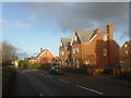
Old School Cottages
Houses on Dormans High Street opposite St John's Church. This is clearly not a converted school building, so presumably they stand on the site of a former school.
Image: © Stephen Craven
Taken: 4 May 2011
0.24 miles
9
Junction of New Farthingdale with the High Street
Image: © Basher Eyre
Taken: 19 Dec 2015
0.24 miles