IMAGES TAKEN NEAR TO
Chellows Lane, LINGFIELD, RH7 6LU
Introduction
This page details the photographs taken nearby to Chellows Lane, RH7 6LU by members of the Geograph project.
The Geograph project started in 2005 with the aim of publishing, organising and preserving representative images for every square kilometre of Great Britain, Ireland and the Isle of Man.

There are currently over 7.5m images from over14,400 individuals and you can help contribute to the project by visiting https://www.geograph.org.uk
Image Map
Images are licensed for reuse under creativecommons.org/licenses/by-sa/2.0
Notes
- Clicking on the map will re-center to the selected point.
- The higher the marker number, the further away the image location is from the centre of the postcode.
Image Listing (30 Images Found)
Images are licensed for reuse under creativecommons.org/licenses/by-sa/2.0
Image
Details
Distance
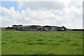
2
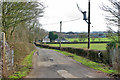
Road to Chellows Farm and Chellows Park
A private road but public footpath.
Image: © Robin Webster
Taken: 24 Jan 2010
0.01 miles
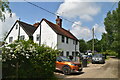
5
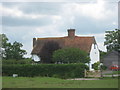
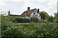
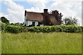
Old Chellows Farmhouse
Grade II listed building near Chellows Farm.
See http://www.britishlistedbuildings.co.uk/en-287344-old-chellows-crowhurst for more details.
Image: © David Anstiss
Taken: 10 Jul 2011
0.05 miles
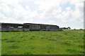
8
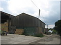
Barns at Chellows Farm
Beside Chellows Lane, leading from Chellows Park towards Caterfield Lane.
Image: © David Anstiss
Taken: 10 Jul 2011
0.07 miles