IMAGES TAKEN NEAR TO
Newchapel Road, LINGFIELD, RH7 6LE
Introduction
This page details the photographs taken nearby to Newchapel Road, RH7 6LE by members of the Geograph project.
The Geograph project started in 2005 with the aim of publishing, organising and preserving representative images for every square kilometre of Great Britain, Ireland and the Isle of Man.

There are currently over 7.5m images from over14,400 individuals and you can help contribute to the project by visiting https://www.geograph.org.uk
Image Map
Images are licensed for reuse under creativecommons.org/licenses/by-sa/2.0
Notes
- Clicking on the map will re-center to the selected point.
- The higher the marker number, the further away the image location is from the centre of the postcode.
Image Listing (19 Images Found)
Images are licensed for reuse under creativecommons.org/licenses/by-sa/2.0
Image
Details
Distance
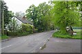
1
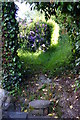
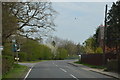
Footpath at Newchapel, Surrey
The footpath leaves the B2028, and dives between the houses.
Image: © Peter Trimming
Taken: 19 Jun 2010
0.07 miles
2
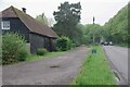
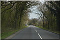
Barn Conversion by the B2028
The blue sign was advertising Gatwick Scuba.
Image: © Glyn Baker
Taken: 2 May 2024
0.08 miles
3
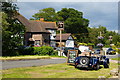
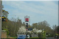
Blacksmith's Head, Newchapel, Surrey
A busy public house on the B2028. The car helps to advertise a forth-coming event.
Image: © Peter Trimming
Taken: 19 Jun 2010
0.08 miles
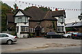
9
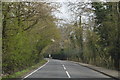
Horne Bridleway 257 Crossing Newchapel Road
The B2028 at Yew Tree Cottage
Image: © Glyn Baker
Taken: 2 May 2024
0.19 miles
10
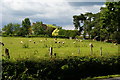
View Towards Shawlands, Newchapel, Surrey
Looking across the field, towards the farm complex.
Image: © Peter Trimming
Taken: 19 Jun 2010
0.20 miles