IMAGES TAKEN NEAR TO
Oldencraig Mews, LINGFIELD, RH7 6GU
Introduction
This page details the photographs taken nearby to Oldencraig Mews, RH7 6GU by members of the Geograph project.
The Geograph project started in 2005 with the aim of publishing, organising and preserving representative images for every square kilometre of Great Britain, Ireland and the Isle of Man.

There are currently over 7.5m images from over14,400 individuals and you can help contribute to the project by visiting https://www.geograph.org.uk
Image Map
Images are licensed for reuse under creativecommons.org/licenses/by-sa/2.0
Notes
- Clicking on the map will re-center to the selected point.
- The higher the marker number, the further away the image location is from the centre of the postcode.
Image Listing (40 Images Found)
Images are licensed for reuse under creativecommons.org/licenses/by-sa/2.0
Image
Details
Distance
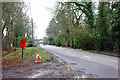
2
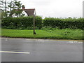
Fingerpost and stile
Public footpath 251 adjacent to property in Tandridge Lane.
Image: © Peter Holmes
Taken: 30 May 2013
0.08 miles
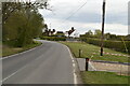
6
A Sunday spin on Tandridge Lane
An elderly open car (make not noted) keeps well out from the verge - probably just in case of potholes, which were frequent after the hard frosts and snow earlier in the month.
Image: © Robin Webster
Taken: 24 Jan 2010
0.09 miles
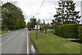
7
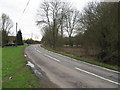
Tandridge lane looking south west towards Ray lane, near Blindley Heath, Surrey
Image: © Richard Rogerson
Taken: 24 Jan 2010
0.10 miles