IMAGES TAKEN NEAR TO
Bannisters Croft, LINGFIELD, RH7 6GS
Introduction
This page details the photographs taken nearby to Bannisters Croft, RH7 6GS by members of the Geograph project.
The Geograph project started in 2005 with the aim of publishing, organising and preserving representative images for every square kilometre of Great Britain, Ireland and the Isle of Man.

There are currently over 7.5m images from over14,400 individuals and you can help contribute to the project by visiting https://www.geograph.org.uk
Image Map
Images are licensed for reuse under creativecommons.org/licenses/by-sa/2.0
Notes
- Clicking on the map will re-center to the selected point.
- The higher the marker number, the further away the image location is from the centre of the postcode.
Image Listing (25 Images Found)
Images are licensed for reuse under creativecommons.org/licenses/by-sa/2.0
Image
Details
Distance
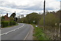
1
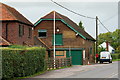
Bannisters Bakery, Blindley Heath
Located on the usually busy Eastbourne Road (A22). Some years ago, the building also included a tea room.
Image: © Peter Trimming
Taken: 17 Sep 2011
0.00 miles
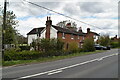
2
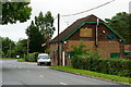
Bannisters Bakery, Blindley Heath
Located on the usually busy Eastbourne Road (A22). Some years ago, the building also included a tea room.
Image: © Peter Trimming
Taken: 17 Sep 2011
0.01 miles