IMAGES TAKEN NEAR TO
St. Christophers, High Street, LINGFIELD, RH7 6AQ
Introduction
This page details the photographs taken nearby to St. Christophers, High Street, RH7 6AQ by members of the Geograph project.
The Geograph project started in 2005 with the aim of publishing, organising and preserving representative images for every square kilometre of Great Britain, Ireland and the Isle of Man.

There are currently over 7.5m images from over14,400 individuals and you can help contribute to the project by visiting https://www.geograph.org.uk
Image Map
Images are licensed for reuse under creativecommons.org/licenses/by-sa/2.0
Notes
- Clicking on the map will re-center to the selected point.
- The higher the marker number, the further away the image location is from the centre of the postcode.
Image Listing (169 Images Found)
Images are licensed for reuse under creativecommons.org/licenses/by-sa/2.0
Image
Details
Distance
1

Village Cross and Cage, Lingfield
Also known as the Old Gaol, St Peters Cross was built in 1473 to designate the boundary of two manors. However it also served as a gaol, wording on a plaque says 'the cage for the detention of petty offenders added in 1773 was last used in 1882 to detain poachers'.
Image: © Richard Rogerson
Taken: 5 Jun 2010
0.02 miles
4
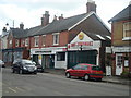
"Lingfield Tandoori" - clearly once a chapel - in Lingfield, Surrey
Image: © Ruth Sharville
Taken: 29 Aug 2010
0.04 miles
7
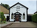
St.Bernard's Catholic Church, Lingfield, Surrey
Located just off Vicarage Road.
Image: © Peter Trimming
Taken: 19 Jun 2010
0.05 miles
10
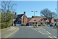
Mini roundabout, Lingfield
The B2028 bears round to the left, becoming the High Street. Right is East Grinstead Road.
Image: © Robin Webster
Taken: 17 Apr 2021
0.06 miles