IMAGES TAKEN NEAR TO
Peeks Brook Lane, HORLEY, RH6 9SX
Introduction
This page details the photographs taken nearby to Peeks Brook Lane, RH6 9SX by members of the Geograph project.
The Geograph project started in 2005 with the aim of publishing, organising and preserving representative images for every square kilometre of Great Britain, Ireland and the Isle of Man.

There are currently over 7.5m images from over14,400 individuals and you can help contribute to the project by visiting https://www.geograph.org.uk
Image Map
Images are licensed for reuse under creativecommons.org/licenses/by-sa/2.0
Notes
- Clicking on the map will re-center to the selected point.
- The higher the marker number, the further away the image location is from the centre of the postcode.
Image Listing (41 Images Found)
Images are licensed for reuse under creativecommons.org/licenses/by-sa/2.0
Image
Details
Distance
1
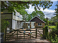
Bungalow on Peeks Brook Lane
Once called 'Wings', it may still be, but it has been absorbed into the new Greyhound Trust establishment off to the left and appears to be in the course of refurbishment. The apparently over the top site cabins were presumably mainly for the extensive kennels and associated buildings.
Image: © Robin Webster
Taken: 21 May 2022
0.01 miles
2
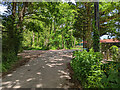
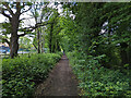
Peeks Brook Lane heading north
The end of the tarmac, the lane continues straight on as an unsurfaced byway.
Image: © Robin Webster
Taken: 21 May 2022
0.02 miles
3
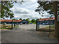
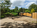
National Greyhound Centre
The Greyhound Trust's new establishment for 'retired' greyhounds.
Image: © Robin Webster
Taken: 21 May 2022
0.03 miles
4
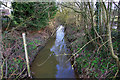
Burstow Stream
Viewed from the Peeks Brook Lane bridge.
Image: © Robin Webster
Taken: 28 Jan 2010
0.03 miles
5
Peeks Brook Lane heading south
Over this part, byway 369 Horley.
Image: © Robin Webster
Taken: 21 May 2022
0.04 miles
6
Gates off Peeks Brook Lane
The posh gates are for a house called Roughs Corner.
Image: © Robin Webster
Taken: 21 May 2022
0.04 miles
7
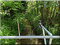
Burstow Stream at Peeks Brook Lane
Looking upstream with a traditional depth gauge and a modern remote sensor, station 7255. At this time the recorded depth was 1.03 m. The highest level recorded here was 2.90 m on Christmas Eve, 2013.
Image: © Robin Webster
Taken: 21 May 2022
0.04 miles
8
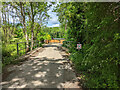
Peeks Brook Lane crosses Burstow Stream
This is the only significant watercourse encountered by the lane over its entire length. 'Burstow Stream' sounds like a modern drainage authority name - it seems likely its old name was Peeks Brook. Old maps do not give it any name.
Image: © Robin Webster
Taken: 21 May 2022
0.04 miles
9

Peeks Brook Lane heading north
The road becomes a byway here, but remains tarmac for a short distance for better premises access.
Image: © Robin Webster
Taken: 21 May 2022
0.05 miles
10

Burstow Stream at Peeks Brook Lane
Looking downstream.
Image: © Robin Webster
Taken: 21 May 2022
0.06 miles