IMAGES TAKEN NEAR TO
Ontario Close, HORLEY, RH6 9RA
Introduction
This page details the photographs taken nearby to Ontario Close, RH6 9RA by members of the Geograph project.
The Geograph project started in 2005 with the aim of publishing, organising and preserving representative images for every square kilometre of Great Britain, Ireland and the Isle of Man.

There are currently over 7.5m images from over14,400 individuals and you can help contribute to the project by visiting https://www.geograph.org.uk
Image Map
Images are licensed for reuse under creativecommons.org/licenses/by-sa/2.0
Notes
- Clicking on the map will re-center to the selected point.
- The higher the marker number, the further away the image location is from the centre of the postcode.
Image Listing (28 Images Found)
Images are licensed for reuse under creativecommons.org/licenses/by-sa/2.0
Image
Details
Distance
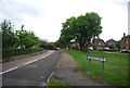
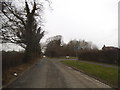
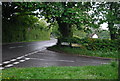
3
Perrylands Lane
Just the usual trees - no pear trees now.
Image: © Robin Webster
Taken: 28 Jan 2010
0.06 miles
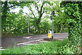
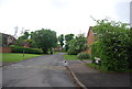
9
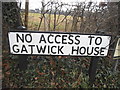
Pre-Worboys sign on the corner of Perrylands Lane, Smallfield
Gatwick House is an office block along the road but with a blockage in this direction.
Image: © David Howard
Taken: 6 Feb 2017
0.07 miles