IMAGES TAKEN NEAR TO
Careys Wood, HORLEY, RH6 9PB
Introduction
This page details the photographs taken nearby to Careys Wood, RH6 9PB by members of the Geograph project.
The Geograph project started in 2005 with the aim of publishing, organising and preserving representative images for every square kilometre of Great Britain, Ireland and the Isle of Man.

There are currently over 7.5m images from over14,400 individuals and you can help contribute to the project by visiting https://www.geograph.org.uk
Image Map
Images are licensed for reuse under creativecommons.org/licenses/by-sa/2.0
Notes
- Clicking on the map will re-center to the selected point.
- The higher the marker number, the further away the image location is from the centre of the postcode.
Image Listing (25 Images Found)
Images are licensed for reuse under creativecommons.org/licenses/by-sa/2.0
Image
Details
Distance
6
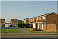
The Cravens
A 1970s(?) development off Weatherhill Road.
Image: © Ian Capper
Taken: 21 Apr 2011
0.14 miles
7
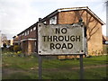
Wooden no through road sign at the entrance to Churchill Close
The font vaguely imitates the pre-Worboys style, but probably made by the council when they were running short of metal a little later than 1964.
Image: © David Howard
Taken: 29 Mar 2015
0.15 miles