IMAGES TAKEN NEAR TO
Weatherhill Road, HORLEY, RH6 9NG
Introduction
This page details the photographs taken nearby to Weatherhill Road, RH6 9NG by members of the Geograph project.
The Geograph project started in 2005 with the aim of publishing, organising and preserving representative images for every square kilometre of Great Britain, Ireland and the Isle of Man.

There are currently over 7.5m images from over14,400 individuals and you can help contribute to the project by visiting https://www.geograph.org.uk
Image Map
Images are licensed for reuse under creativecommons.org/licenses/by-sa/2.0
Notes
- Clicking on the map will re-center to the selected point.
- The higher the marker number, the further away the image location is from the centre of the postcode.
Image Listing (24 Images Found)
Images are licensed for reuse under creativecommons.org/licenses/by-sa/2.0
Image
Details
Distance
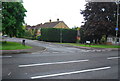
2
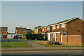
The Cravens
A 1970s(?) development off Weatherhill Road.
Image: © Ian Capper
Taken: 21 Apr 2011
0.12 miles
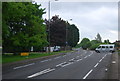
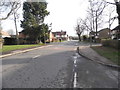
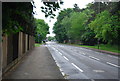
5
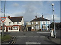
Chapel Road at the junction of Weatherhill Road
Image: © David Howard
Taken: 29 Mar 2015
0.13 miles
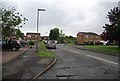
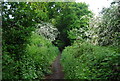
6
Burstow Primary School, Wheelers Lane, Smallfield, RH6 9PT
Looking North from Wheelers Lane entrance near junction with Redehall Road.
Image: © Rib
Taken: 14 Jan 2006
0.13 miles