
IMAGES TAKEN NEAR TO
Station Road, HORLEY, RH6 9HL
Introduction
This page details the photographs taken nearby to Station Road, RH6 9HL by members of the Geograph project.
The Geograph project started in 2005 with the aim of publishing, organising and preserving representative images for every square kilometre of Great Britain, Ireland and the Isle of Man.

There are currently over 7.5m images from over14,400 individuals and you can help contribute to the project by visiting https://www.geograph.org.uk
Image Map
Images are licensed for reuse under creativecommons.org/licenses/by-sa/2.0
Notes
- Clicking on the map will re-center to the selected point.
- The higher the marker number, the further away the image location is from the centre of the postcode.
Image Listing (115 Images Found)
Images are licensed for reuse under creativecommons.org/licenses/by-sa/2.0
Image
Details
Distance
1

Station Road
Viewed from the footbridge in Image, this eastern section of the original much longer Station Road has retained its name, unlike the western section, now High Street (see Image). The shops on the right can be seen to have originally been houses (built in the late 1890s/early 1900s), with shop fronts added later.
Image: © Ian Capper
Taken: 25 Jul 2009
0.01 miles
2
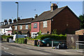
Balcombe Road
Cottages to the south of the Station Road/Smallfield Road/Balcombe Road crossroads.
Image: © Ian Capper
Taken: 27 May 2013
0.03 miles
3
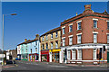
Station Road
Looking along Station Road from where it meets Balcombe Road.
Image: © Ian Capper
Taken: 27 May 2013
0.03 miles
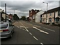
5

Elizabeth II postbox on Balcombe Road, Horley
Postbox No. RH6 218.
See Image] for context.
Image: © JThomas
Taken: 31 Mar 2025
0.04 miles
6
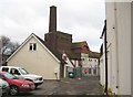
Horley: The former Albert Brewery
The brewery was built circa 1850 on the north side of Station Road and east of the railway. Although long since defunct as a brewery, it is now a locally listed building by Reigate and Banstead Borough Council.
Image: © Nigel Cox
Taken: 9 Dec 2012
0.04 miles
7
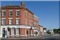
Old Bank Chambers
Former Lloyds Bank at the junction of Station Road and Balcombe Road.
Image: © Ian Capper
Taken: 27 May 2013
0.04 miles
8

Balcombe Road (B2036), Horley
Showing position of Postbox No. RH6 218.
See Image] for postbox.
Image: © JThomas
Taken: 31 Mar 2025
0.04 miles
9
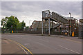
Footbridge near site of former Horley Station
This footbridge crosses the London to Brighton railway line and links Station Road (in the foreground, turning into Station Approach on the left) and High Street (beyond the bridge). Until 1903, the road (then called Station Road throughout) crossed the railway at a level crossing, with the 1841 Horley Station immediately to the south. The quadrupling of the railway in 1905 led to the crossing being severed and replaced by a subway (the entrance to which can be seen to the left of the photo), with this footbridge being added later. At the same time the station was moved around 300 metres to the south, with a station building on a new Victoria Road overbridge (this too had previously crossed the railway at a level crossing), as seen in the background in Image
Image: © Ian Capper
Taken: 25 Jul 2009
0.05 miles
