IMAGES TAKEN NEAR TO
Grovelands, HORLEY, RH6 9HE
Introduction
This page details the photographs taken nearby to Grovelands, RH6 9HE by members of the Geograph project.
The Geograph project started in 2005 with the aim of publishing, organising and preserving representative images for every square kilometre of Great Britain, Ireland and the Isle of Man.

There are currently over 7.5m images from over14,400 individuals and you can help contribute to the project by visiting https://www.geograph.org.uk
Image Map
Images are licensed for reuse under creativecommons.org/licenses/by-sa/2.0
Notes
- Clicking on the map will re-center to the selected point.
- The higher the marker number, the further away the image location is from the centre of the postcode.
Image Listing (121 Images Found)
Images are licensed for reuse under creativecommons.org/licenses/by-sa/2.0
Image
Details
Distance
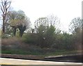
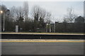
1
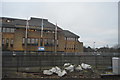
Grovelands
Apartment block on The Grove built in 1968/9 on the site of a house of the Same name.
Image: © Ian Capper
Taken: 29 Dec 2013
0.01 miles
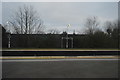
3
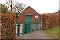
Brethren's Meeting Room
In The Grove by its junction with Fairlawns.
Image: © Ian Capper
Taken: 9 Mar 2010
0.02 miles
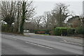
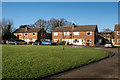
4
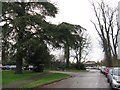
Autumn at Autumn Close, Horley
Autumn Close leads off to the left from The Grove.
Image: © Dave Spicer
Taken: 28 Nov 2012
0.03 miles
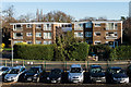
5
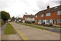
Fairlawns
A 1958 development off The Grove.
Image: © Ian Capper
Taken: 9 Mar 2010
0.04 miles
7
Fairlawns
Cul-de-sac off The Grove built in 1958.
Image: © Ian Capper
Taken: 29 Dec 2013
0.06 miles