IMAGES TAKEN NEAR TO
Stockfield, HORLEY, RH6 9DP
Introduction
This page details the photographs taken nearby to Stockfield, RH6 9DP by members of the Geograph project.
The Geograph project started in 2005 with the aim of publishing, organising and preserving representative images for every square kilometre of Great Britain, Ireland and the Isle of Man.

There are currently over 7.5m images from over14,400 individuals and you can help contribute to the project by visiting https://www.geograph.org.uk
Image Map
Images are licensed for reuse under creativecommons.org/licenses/by-sa/2.0
Notes
- Clicking on the map will re-center to the selected point.
- The higher the marker number, the further away the image location is from the centre of the postcode.
Image Listing (17 Images Found)
Images are licensed for reuse under creativecommons.org/licenses/by-sa/2.0
Image
Details
Distance
1
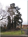
Tree on the corner of The Fieldings, Horley
Image: © David Howard
Taken: 29 Mar 2015
0.12 miles
2
Collingwood Close
1983 cul-de-sac off Wheatfield Way.
Image: © Ian Capper
Taken: 17 Jul 2013
0.13 miles
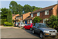
3
Houses on the corner of The Fieldings and Wheatfield Way
Image: © David Howard
Taken: 29 Mar 2015
0.14 miles
4
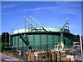
Gas Holder, Horley
Near Gatwick Metro Centre, an industrial area adjacent to Balcombe Road.
Image: © Rib
Taken: 11 Jul 2006
0.17 miles
5
It's a grey day
An overcast sky over Langshott
Image: © Kurseong Carl
Taken: 22 Jan 2011
0.18 miles
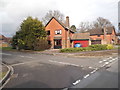
6
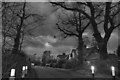
The Farmhouse, Horley
Like most pubs in the UK at the moment, the Farmhouse is shut due to the Coronavirus
Image: © Richard Rogerson
Taken: 5 Apr 2020
0.19 miles
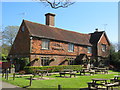
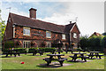
7
The Farmhouse
Pub on Ladbroke Road. Originally built in the 17th Century as Hewitt's Farmhouse, it became a pub in 1985, serving the nearby Langshott estate. Grade II listed - see https://www.historicengland.org.uk/listing/the-list/list-entry/1039978.
Image: © Ian Capper
Taken: 2 Aug 2015
0.19 miles
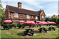
8
The Farmhouse
Pub on Ladbroke Road. Originally built in the 17th Century as Hewitt's Farmhouse, it became a pub in 1985, serving the nearby Langshott estate. Grade II listed - see https://www.historicengland.org.uk/listing/the-list/list-entry/1039978.
Image: © Ian Capper
Taken: 2 Aug 2015
0.19 miles
9
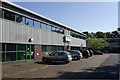
Gatwick Metro Centre
Units in Gatwick Metro Centre, a small industrial estate off Balcombe Road.
Image: © Ian Capper
Taken: 27 May 2013
0.20 miles
10
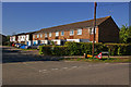
Tanyard Way
Presumably once the site of a tannery, although nothing is shown on old maps, dating from the early 19th century through to the late 1980s, when these houses were built.
Image: © Ian Capper
Taken: 26 Apr 2009
0.21 miles